
The old missions of Baja California are artifacts from the past. Of the twenty-seven missions, eight are intact stone-built churches from the 1700s. The others are in ruins, vanished, or replaced by modern churches in the 1900s. Pages from the 2016-2026 book by David Kier, Baja California Land of Missions, are included below.
In 2026, after a 10-year-run of printing new copies of my book, I am here going to share my collection of photographs, maps, site plans, and the chapter from my book for each mission. Some missions have or had ruins at multiple locations as nearly half of the missions relocated for better water sources or other reasons. Some mission albums will have these other sites on the same page and some will have separate albums for the other site.
Missions listed from north to south:
Mission El Descanso photo and info page
Mission Guadalupe del Norte photo and info page
Mission San Miguel photo and info page
Mission Santa Catalina photo and info page
Mission Santo Tomás (three sites) photo and info page
Mission San Vicente photo and info page
Mission San Pedro Mártir photo and info page
Mission Santo Domingo photo and info page
Mission El Rosario de Arriba photo and info page
Mission El Rosario de Abajo photo and info page
Mission San Fernando photo and info page
Mission Santa María photo and info page
Calamajué mission site photo and info page
Mission San Borja photo and info page
Mission Santa Gertrudis photo and info page
Mission San Ignacio photo and info page
Mission Guadalupe (del Sur) photo and info page
Mission Santa Rosalía de Mulegé photo and info page
Mission La Purísima photo and info page
Mission San José de Comondú (both sites) photo and info page
San Bruno, 1683-1685 fort & colony site
Mission Loreto photo and info page
Mission San Javier photo and info page
Mission Ligüí photo and info page
Mission Los Dolores (both sites) photo and info page
Mission San Luis Gonzaga photos and info page
Mission La Paz/ Todos Santos (three sites) photos and info page
Mission Santiago photo and info page
Mission Santa Rosa photo and info page
Mission San José de Cabo photo and info page
The “Lost Missions” of Baja California
See the Visitas (ruins of satellite mission visiting chapels)
See the mission road, El Camino Real on Google Earth and maps
Quick look Mission & Visita Photos, north to south
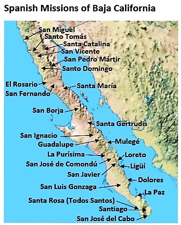
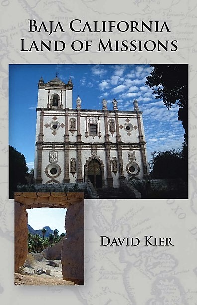
The mission history is quite interesting and detailed. Several books attempted to tell the story of many or all the missions beginning with Zephyrin Engelhardt’s 1908 & 1929 editions of ‘The Missions & Missionaries of California, Vol. 1 Lower California‘. Travel adventure books and road-guide books gave some details on the missions. Other published mission history sources include: Peveril Meigs’ 1935 ‘The Dominican Frontier of Lower California‘; Peter Masten Dunne’s 1952 ‘Black Robes in Lower California‘; Albert Bertrand Nieser’s 1960 ‘The Dominican Mission Foundations in Baja California, 1769-1822‘; Marquis McDonald’s 1968 ‘Baja: Land of Lost Missions‘; Walt Wheelock’s 1971 ‘Byroads of Baja‘; Choral Pepper’s 1973 & 1975 editions of ‘Baja California: Vanished Missions, Lost Treasures, Strange Stories Tall & True‘; W. Michael Mathes’ 1977 ‘The Mission of Baja California‘; Tomás Robertson’s 1978 ‘Baja California and its Missions‘; Harry Crosby’s 1994 ‘Antigua California‘; Edward W. Vernon’s 2002 ‘Las Misiones Antiguas, The Spanish Missions of Baja California‘; Dave Werschkul’s 2003 ‘Saints and Demons in a Desert Wilderness’; Robert Jackson’s 2005 ‘The Missions and the Frontiers of Spanish America‘; David Burckhalter’s 2013 ‘Baja California Missions, In the Footsteps of the Padres‘; and David Kier’s 2016 ‘Baja California Land of Missions‘.
The following is from the book Baja California Land of Mission:
California Discovered
California was first believed to be an island with the name coming from the popular novel Las sergas de Esplandián with its romantic description of a land ruled by women who were “armed with gold, as they knew of no other metal.” Such visions must have had the effect of attracting explorers. California became the name for the land from Cabo San Lucas north. There was no Baja (Lower) California until there was an Alta (Upper) California, and that was not until the Spanish occupied Alta California, following the expedition of 1769. The terms Antigua (Old) and Nueva (New) were also used to describe the peninsula and the “new” land to the north.
The first landing of Spanish sailors on the shores of California was made in late 1533 or in 1534. The exact date is unknown since the landing was made by a crew who were on the run after a mutiny. They were led by Fortún de Jiménez and are believed to have landed at or near La Paz. Jiménez and twenty others were killed by the natives. The survivors re-crossed the Gulf of California to report on the event and on the abundance of black pearls they had seen.
On or about May 5, 1535, the conqueror of Mexico himself, Hernán Cortés, came to California and attempted to build a colony at La Paz, he named the place Santa Cruz. It lasted less than two years because the land and its people were too harsh, and most of the colonists Cortés brought over had perished.
On July 8, 1539, Cortés sent Francisco de Ulloa with three ships to explore the west coast of Mexico. Ulloa went north to the head of the gulf, then came south along the eastern shore of California, proving it was not an island as had been envisioned. Ulloa rounded Cabo San Lucas and sailed north again over halfway up the peninsula before returning to Acapulco. The California as an island idea would not die so easily, and maps continued to show California surrounded by the sea. More expeditions would try to prove or disprove that theory.
In 1540, Hernando de Alarcón sailed north to the Colorado River Delta while Melchior Díaz led a land expedition north, and is believed to have gone into California, making Díaz the first European to come to California by crossing the desert instead of the sea. Both men were part of the Francisco Vázquez de Coronado expedition to explore the north. Díaz died from a bizarre injury shortly after crossing the Colorado River into California. Where Melchior Díaz was buried has been a mystery for close to 500 years (see page 227 for the Díaz story link). Documents and maps from the voyages of Ulloa and Alarcón named the new land California.
In 1542, Juan Rodríguez Cabrillo sailed up the west coast of California and landed several times, naming points and bays northbound, and eventually came into San Diego Bay (calling it San Miguel). Cabrillo continued to sail north and reached the Channel Islands, where he died from a leg injury.
In 1596, Sebastián Vizcaíno established a colony at Cabo San Lucas that lasted only two months. In 1602, Vizcaíno led an expedition of 200 men on three ships up the California coast. Vizcaíno would give his own chosen names to many locations that Cabrillo had previously discovered and named. That is how San Miguel became San Diego, for example. At least sixteen more voyages across the gulf were made by 1668 to exploit the peninsula for its potential wealth, and most failed. Priests sometimes traveled to California on these expeditionary ships with hopes of converting the native population to Christianity. In September 1668, Padre Juan Cavallero Carranco documented the time spent with Captain Francisco de Lucenilla. The final lines of Padre Cavallero’s report illustrate the difficulties and disappointments of this and perhaps previous California expeditions:
“All of the California Indians are poor and naked, and there is no need to seek riches from them for each gives what he has. I conclude by stating again that no private individual should attempt to carry out this conquest; and particularly they should not be poor, since then all will be ruined and fail as has happened on more than twenty voyages which have been made. However, if Our King and Lord (may God guard him) counsels all those who go, they will do the greatest service to God imaginable by removing a great number of souls from the devil’s power. With this I end the true report of the unhappy voyage to the Californias.”
Fifteen years would pass until the next expedition to California.
Why Spanish Missions are in Baja California
The Spanish government used the Catholic Church to help it colonize the New World; the church was ambitious to convert native people to Christianity. That process was deemed the best method to instruct the local population how to live and work like Europeans and speak Spanish. The native Indians of California were generally referred to by the missionaries and Spaniards as gentiles, pagans, heathens, or savages before they joined the mission and as neophytes after joining. The word “reduced” is also used by missionary writers to indicate those natives who have been assimilated (baptized) into the Catholic faith.
When the Spanish soldiers and Catholic priests arrived in the Indian homeland, they were usually met with either curiosity or hostility. Sometimes one was followed by the other, but eventually the mission would be established. Using food to entice them, missionaries could get the Indians to provide labor to help build the mission and to help with agriculture and livestock.
A mission was not simply a church, but an entire enterprise that would be the center of a community. Irrigation canals (acequias) and reservoirs (pilas) for the crops were a vital part of the mission. Missions were named for saints or holy sites that often shared the name of a financial sponsor’s family member. The Indian name for the location was often attached which helped distinguish one mission from others with the same saint’s name.
Missions were founded throughout the Western Hemisphere for some 200 years before advancing to California. The missionaries trained at and received supplies from the missions in Mexico which made the California mission program possible.
Missions had the objective to convert the Indians from hunter/gatherers to becoming farmers tending crops and livestock. As new colonists would arrive in California, they would live among fellow Spanish citizens and not be in fear of attack as had occurred to some of the first European arrivals. Another goal of the missions was to develop ports along the Pacific Coast to resupply the Manila Galleon enroute from Asia to Acapulco between the years 1565 and 1815.
Mission churches and altars were designed to dazzle the converts. Most of the native Californians had never seen walls with a roof above and had never heard the sound of large ringing bells. Paintings of the saints and benefactors were framed in gold leaf. Once the huge stone churches were built, especially in these remote locations, the curiosity and awe-inspiring size was amazing to the primitive population as much as it is to travelers today.
Usually, a mission center (cabecera) had some satellite chapels with farms. These were known as visitas (mission visiting stations). The mission priest would visit them periodically and conduct services. Visitas were typically located at existing Indian settlements (rancherías) that also had a good supply of water. Some visitas were very productive and had large stone chapels. Some would become missions, but a few mission sites would later be reduced in importance to being only a visita. Rancherías sometimes were relocated as the Indian tribes were often nomadic within a defined territory, following food sources. Some of the visita ruins were impressive and mistaken for being missions by more modern travelers. The best known visitas of Baja California include San Juan Londó, Magdalena, La Presentación, San Miguel (de Comondú), San Pablo, San Juan de Dios, and San Telmo. Ruins at Londó and San Pablo remain impressive to see into the twenty-first century. Most others have collapsed into rubble, been washed away by floods, or plowed over by farmers.
Missions in California were founded by three Catholic Orders: The Jesuits (1683-1767), the Franciscans (1769-1823), and the Dominicans, also known as “The Order of Preachers” (1774-1834). While all three orders belong to the same church, each order has unique solemn vows, teachings, and practices. Unlike the other orders that replaced them in California, the Jesuits did not restrict or imprison the Indians who joined their missions.
The Jesuits, often referred to as the Black Robes for their manner of dress, immersed themselves into the native Indian languages so as to be better able to teach and gain their needed cooperation. What the Jesuits did that was not always popular was insist the Indians destroy their idols and religion and give up polygamy. The Pericú Revolt of 1734 was inflamed by these imposed rules.
Establishing a Jesuit mission had specific requirements. Once a suitable site was found, permission was obtained, financing was found, and a priest had to be made available. The lack of Jesuit priests often delayed opening a new mission for long periods. When the Jesuits were removed and replaced with the Franciscans, this arrangement ended, and mission operations would be placed under civil authority and control.
All sixteen of the Jesuits in California were removed from their missions and taken from the peninsula in February 1768. The Franciscan Order, chosen to replace the Jesuits, arrived to take on their duties in April 1768. Within a year, the Spanish government gave Junípero Serra (Franciscan president of the California missions) the task of occupying Nueva California, the land to the north of the peninsula. Spain was concerned that Russia or England would soon advance on it. The name of the peninsula was now modified to either Antigua (Old) California or Baja (Lower) California.
The Franciscans and later the Dominicans, under civil authority, were tasked with the continued conversion of California for Spain. The Indians began to be treated more as tools to achieve that goal. They were forced to stay at the missions once they joined the church and the men were beaten for a variety of reasons. The native Californians never achieved the equality of citizenship during the mission years.
The missionaries established and operated twenty-five missions on the peninsula of California for Spain. Two more missions were established by a Dominican priest during the Mexican period that followed. Those two are not universally accepted as true missions by all historians. In Alta California, nineteen missions were founded for Spain. Two more were founded during the Mexican period as well.
Missionaries often found it necessary to relocate their missions, usually to a better source of water for irrigation. Almost half the missions moved some distance, and a few moved as much as ten to fifty miles (see also page 183).
A mission’s name was sometimes changed or altered with the move and sometimes not. This caused confusion about Baja California missions for some, in past years.
Today, we use the word “mission” to apply to the church building itself or ruins of the former church buildings. However, when missions were operating, it was a more encompassing enterprise than just a church. Missions resembled a small colony, with agriculture, irrigation, hospital, and often a military presence.
The Missions and Missionaries
Jesuits
Padre Eusebio Francisco Kino and Padre Matías Goñi with soldiers commanded by Admiral Isidro de Atondo y Antillón sailed to La Paz, arriving on April 1, 1683, to begin a colony. Their new mission was named Guadalupe, but it failed to enlist many of the hostile coastal Indians. When supplies also failed to arrive, they abandoned the seaside colony on July 14, 1683. As a final insult, the Spanish soldiers needlessly fired their cannon on the natives dooming any hopes of bringing the California Indians into their trust. See map on page 60.
Once the Spanish regrouped on the mainland, they made another crossing. With the second attempt, a new mission colony at San Bruno, fifteen miles north of Loreto, was begun on October 6, 1683. The Indians were friendlier at San Bruno and that eliminated one problem for the Spaniards. In August 1684, Padre Jean Baptiste Copart arrived to assist his brother Jesuits.
Kino and Atondo were able to explore the land to the west in December 1684. They were the first Europeans to reach the Pacific Coast of California by land. San Bruno survived longer than Guadalupe at La Paz but was abandoned on May 8, 1685. Reasons included the lack of good water, outbreaks of scurvy, and not having enough provisions needed to survive. Remains of the hilltop Spanish fort at San Bruno are the oldest European ruins of any kind in Lower or Upper California. Located 3.8 miles east from Highway 1 at Km. 26. A 4WD vehicle, GPS device, and a short hike is required to insure reaching the site.
Padre Kino came to realize that for missions to be successful in California they would need to be supported for a time by the missions across the gulf in Mexico. Kino also concluded that any success in California would necessitate that Spanish soldiers be placed under Jesuit control. A dozen years would pass before the Jesuits could try again.
Spain agreed to the Jesuit proposal for autonomy over the California missions and soldiers, but the Jesuits would have to obtain their own financing for the enterprise. A Pious Fund was established to secure endowments from wealthy Europeans for the California missions. See Appendix E on page 211.
Once permission to return to California was granted by the Mexican Viceroy on February 5, 1697, Padre Juan María de Salvatierra worked closely with Kino on the project. Sadly, for Kino, he would be prevented from joining Salvatierra because of some Indian uprisings on the mainland that his superiors believed only he could resolve. Padre Francisco María Píccolo would follow Salvatierra to California in place of Kino.
A permanent California occupation for Spain began with the founding of the mission at Loreto in 1697. The Jesuit Order would establish seventeen missions, numerous mission satellite chapels and farms, and a network of well-built roads, all on what had been thought by many to be an island. Once California was confirmed as being attached to the continent by the 1746 Padre Fernando Consag sea expedition, efforts got under way to establish missions to the north.
For over seventy years the Jesuit Order of priests operated the missions. The Jesuits purpose in California was to learn the Indian languages, convert the natives to Christianity, teach them European methods of living, and to occupy the land for the King of Spain. They needed to have authority over the soldiers to prevent brutality against the Indians. After many years of missionary work, rumors claimed the Jesuits were disrespecting the King’s authority, and amassing great wealth. These rumors spread about the Jesuits later proved to be false. The Jesuits were removed from California practically as prisoners in February of 1768.
Franciscans
In April 1768, the Franciscans led by Padre (now Saint) Junípero Serra arrived to continue the California mission program but under Spanish civil control. The Franciscans were soon given new instructions to expand far north, along the Pacific Coast, and occupy the ports of San Diego and Monterey. This northern territory had no name, so it was simply called New (Nueva) California or Upper (Alta) California. The peninsula began to be referred to as Old (Antigua) California or Lower (Baja) California, after the 1769 Gaspar de Portolá/Junípero Serra expedition to San Diego and Monterey. After just five years, the Franciscans handed over Baja California mission duties to the Dominican Order of Preaching Friars, in May 1773.
Dominicans
The Dominicans operated the missions of Baja California for eighty-two years through a period of growth, dramatic changes, and disappointments. To some historians, their methods were harsh and unbending to the needs of the native Indians they hoped to Christianize and convert to modern living. What is clear is that the Dominicans constructed many missions, including the cut stone churches at San Ignacio, Santa Gertrudis, and San Borja.
The Dominicans inherited a land that was already in decline, yet they performed vaccinations to try to save the lives of those infected by European diseases. They endured years of neglect during two wars (1810-1821 and 1846-1848) and a change of government in Mexico that attempted to secularize their missions. Still, they remained on the peninsula the longest of the three orders assigned to mission duties in California.
The following is a summary of some of the events pertaining to the Dominicans in California, called Baja California after 1769:
July 24, 1768: A request for the administration of some of the Jesuit-founded missions of Baja California was made by Dominican Fray Juan Pedro de Iriarte y Laurnaga. Iriarte was Procurator General for the Province of Santiago de Mexico, residing at the Royal Court of Madrid. He asked especially for those missions between the 25th and 28th degrees of north latitude.
December 17, 1769: King Carlos III decided that ten Dominican fathers, destined for the nearest former Jesuit missions, should go there but left the exact posts unspecified.
January 17, 1770: The Procurator General, Fray Juan de Dios de Cordoba, recommended that Iriarte’s petition be granted, that the requested territory of Baja California be allocated, since there was urgent need for the conquest of Nueva California as a check against foreign encroachment.
June 15, 1770: Juan Pedro de Iriarte and Juan de Dios de Cordova asked the King for a grant of twenty-four missionaries, at royal expense, for the missions of Baja California.
July 10, 1770: Iriarte issued a circular to the convents of the three Spanish Provinces of the Dominican order, announcing that the king had granted them a mission field in Baja California and calling for volunteers.
April 30, 1772: The division of California was settled, and the Dominicans accepted all Baja California while the Franciscans had Alta California, as far north “as they can extend their spiritual conquests.” This arrangement was approved by the Council of the Indies on May 11, 1775.
September 1772: Two boats were used to bring the Dominicans to California from San Blas. Storms separated the boats and disaster fell on one. The storm, disease, and bad food forced one boat back to shore at Mazatlán. On board the doomed boat was their leader, Padre Iriarte. After arriving at Mazatlán, he was taken to San Sebastián, where he died.
October 14, 1772: The successful boat with nine Dominican priests and one lay brother arrived at Loreto. Ten days later one of those priests died. Nearly six months passed before news arrived that the other boat carrying Dominicans had wrecked and their leader, Padre Iriarte, and two other priests had died.
May 12, 1773: The eighteen Dominicans who survived the September shipwreck arrived at Loreto in two different boats that were far more seaworthy. Three days later the padres were given their mission assignments. See Appendix D on page 205. Now with twenty-six Dominicans in California, each of the missions was assigned two, except for the far north missions of Santa María and San Fernando, which shared two priests. The Indian neophytes of Mission Santa María were transferred to Mission San Fernando in 1775.
September 21, 1773: Padre Luis Sáles arrived in Loreto after being delayed by his illness from the disastrous events of a year earlier. Sáles was assigned to Mission Guadalupe.
March 26, 1804 was the date when Alta and Baja California became two separate political districts. Politically it had been just one California before, with forty-four Spanish missions founded. In 1810, Mexico declared its independence from Spain. The final four missions in the Californias are considered “Mexican missions” and were not built with Spain’s influence or involvement.
Mission Names
This book will primarily utilize the common or popular modern name used rather than the full, official name. In the next section are the common names followed by the original, official name. Mission Santa Rosalía de Mulegé is the full name for the mission commonly known simply as Mulegé. Every mission name, spelling, and pronunciation is in Spanish. For example, Mulegé is pronounced “Moo-leh-HAY.” Mission San Luis Gonzaga Chiryaqui was commonly called San Luis during the Spanish period, but in modern times it is known as San Luis Gonzaga. Chiryaqui was the native Indian name for the location.
Official mission names usually stayed with the mission if it moved to a new location. However, after the move, a mission might be called by the new location name, creating confusion as to how many missions existed. La Paz/ Todos Santos; Dolores/ La Pasión; Calamajué/ Santa María; and San Miguel/ El Descanso are examples of one mission known by another name following a relocation.
Baja California Missions
(Founding Year, Common Name, Official Name) [desktop created, cell phone viewing is a bit distorted]
1 – 1697 LORETO Nuestra Señora de Loreto Conchó
2 – 1699 SAN JAVIER San Francisco Javier Biaundó
3 – 1705 LIGÜÍ San Juan Bautista de Ligüí (Malibat)
4 – 1705 MULEGÉ Santa Rosalía de Mulegé
5 – 1708 COMONDÚ San José de Comondú
6 – 1720 LA PURÍSIMA La Purísima Concepción de Cadegomó
7 – 1720 LA PAZ/ TODOS SANTOS Nuestra Señora del Pilar de la Paz
8 – 1720 GUADALUPE Nuestra Señora de Guadalupe de Huasinapí
9 – 1721 LOS DOLORES Nuestra Señora de los Dolores
10 – 1724 SANTIAGO Santiago el Apóstol Aiñiní
11 – 1728 SAN IGNACIO San Ignacio de Kadakaamán
12 – 1730 SAN JOSÉ DEL CABO San José del Cabo Añuití
13 – 1733 SANTA ROSA Santa Rosa de las Palmas
14 – 1737 SAN LUIS GONZAGA San Luis Gonzaga Chiriyaqui
15 – 1752 SANTA GERTRUDIS Santa Gertrudis
16 – 1762 SAN BORJA San Francisco de Borja Adac
17 – 1766 CALAMAJUÉ/ SANTA MARÍA Nuestra Señora de Columna/ Santa María de los Ángeles
The above listed missions were founded by the Jesuits.
18 – 1769 SAN FERNANDO San Fernando de Velicatá
After the Franciscans founded San Fernando, they continued to establish missions from San Diego on north.
The following missions were founded in Baja California by the Dominican Order while the Franciscans were establishing missions in Alta California:
19 – 1774 EL ROSARIO Nuestra Señora del Rosario de Viñadaco
20 – 1775 SANTO DOMINGO Santo Domingo
21 – 1780 SAN VICENTE San Vicente Ferrer
22 – 1787 SAN MIGUEL San Miguel Arcángel
23 – 1791 SANTO TOMÁS Santo Tomás de Aquino
24 – 1794 SAN PEDRO MÁRTIR San Pedro Mártir de Verona
25 – 1797 SANTA CATALINA Santa Catalina Virgen y Mártir
26 – 1810* DESCANSO El Descanso (San Miguel la Nueva) **
27 – 1834 GUADALUPE Nuestra Señora de Guadalupe**
* Year location was developed. New mission built in 1830.
** Not a mission authorized by the Spanish government.
The 2012 book, The Old Missions of Baja & Alta California, 1697-1834, covered the founding of all forty-eight California missions in accurate chronological order. A new, expanded edition was published in 2020 with the title: Old Missions of the Californias.
El Camino Real
The Royal Road, or “King’s Highway” as it is popularly known, connected all the California missions and was expanded to include branches to Indian settlements (rancherías), satellite chapels (visitas), and supply beachheads. Originally, El Camino Real was a pathway for tax revenue to get to the king from all his territories. Many Camino Reals are in the New World. In the Californias, El Camino Real was a communication and supply line rather than a route for tax revenue. The following is part of a report by Jesuit Padre Miguel Venegas. This historical account was completed on November 7, 1739. The name “Camino Real” has been edited into bold font in the following quote for emphasis of how long the mission road system had been called by that name:
“It is this impossibility which the missionaries have sur-mounted by dint of their personal labor, the aid of the Indians already converted and civilized and the assistance of the soldiers. In order that the work might be fairly distributed among all the Indians, in proportion to the advantage which they would derive from the building of these roads, the fathers adhered to the following plan in making this distribution. First of all, they had a main highway camino real built through the center of the mission district extending through its entire area and running lengthwise from south to north. All the rancherías [Indian settlements] belonging to the mission worked together in building this road, for it was of common advantage to them all. Then each ranchería assumed the responsibility for building a special road leading from its settlement and joining the camino real which was, so to speak, the main trunk-line in which all the separate roads from the rancherías terminated. By this means connection was finally made with the headquarters of the mission.
“When these roads were being built it was necessary for the father missionaries to be present and to direct the work. And they had to spend many days in moving about, circling hills and climbing peaks, in order from the summits to spy out the stopping places which were least inaccessible. Moreover, many tools were needed for distribution among the Indians: pickaxes, crowbars, hoes, sledgehammers, shovels, ordinary hammers, levers, ropes, and other tools of this sort. There was least work to be done in the stony areas on the hills and slopes. Yet even here the labors were very great. For the road had to be made wide enough for the passage of animals and pack-trains. The work crews spent many days in removing the loose stones from which they formed low walls or borders along both sides. Nor did they stop until they struck bedrock; thus, in some places they dug to the depth of a vara [33 inches] and in others went even deeper, so that some of the roads were shaped like ditches or the canyons of streams.
“Then came the harder work—the smoothing, insofar as that was possible, with sledgehammers, pickaxes, and crowbars of the outcroppings and jutting points of solid rock which barred the passage of travelers. When their tools did not avail, they had recourse to fire in order to split the rocks and break them up; then they used levers and ropes in order to remove them and set them rolling into the barrancas [ravines] and over the precipices. But the work was most painful and the difficulty greatest when they had to pass over the hills and mountains. This happened very often, since there would be no other place where they could build the road. Here they had to follow routes on steep slopes which fell away into barrancas. In such places they had to contend with the solidity of the mountains and the hardness of the rocks while they labored to break off outcroppings and sharp points and to clear away the stones great and small which lay in the way. In many narrow passes between the hills, where the powers of man were insufficient to break a trail, they were obliged to set thick stakes along the sides and to fill the intervening space with branches and the trunks of trees, putting earth on top, forming bridges, as it were, which would make it possible to pass from one side to the other in these ravines.”
During the Jesuit period (1697-1768), the road was built to high standards and with a great degree of engineering. Much of it can still be seen, 250 to 300 years after it was constructed across the desert and mountains of Baja California. Indeed, many miles are still in use today by ranchers and tourists on mule back.
The Franciscans and Dominicans did not have the same skill or interest in road building as the Jesuits. With only a few exceptions, the Camino Real north of Mission San Borja resembles not much more than a cattle trail — if any trail exists at all. The Jesuits were removed from California before serious road construction to Mission Santa María could be initiated. The route is generally known, thanks to letters from mission-era and post-mission-era travelers. Modern roads have been built over the mission trail in many places. Thanks to many history researchers, we know the route as it travels through Baja California.
One major El Camino Real researcher of the twentieth century was Lower California Guidebook author Howard Gulick, who documented and mapped the mission road from Loreto to El Rosario, in 1954. Another, and maybe better known was Harry Crosby, who began traveling the trail in 1967 as a photographer for a book about the founding of the Alta California missions. Crosby then went on to research his own 1974 book, The King’s Highway in Baja California.
In 1977, Harry Crosby commissioned a series of detailed maps of the Camino Real from Loreto to San Diego. They were published in the Winter 1977 edition of The Journal of San Diego History and can be seen online at www.vivabaja.com at this link: Harry Crosby’s Photos and El Camino Real Details. In 2018, an exciting new map was created by two backpackers, walking the mission trails of Baja California: http://caminorealbaja.com/
El Camino Real also went south from both the Loreto and San Javier missions to connect the many missions in that direction. Ligüí/Malibat, San Luis Gonzaga, Los Dolores, Pilar de la Paz, Santiago, Santa Rosa, and San José del Cabo were all connected by El Camino Real.
The old mission road from Loreto to San Diego is often mentioned in books, but the route from San Diego to San Francisco was made famous with decorative bells created by Mrs. A. S. C. Forbes starting in 1906. Those bells began a tradition that has marked the route to the present time. The old mission trail north of San Diego is now mostly modern paved highways and streets bearing the name “El Camino Real.”
The chapters for each mission is in the photo album for that mission, linked above.
The End of Spanish Control
Mexico and Spain were at war from 1810 to 1821. In 1822, the two Californias pledged their allegiance to Mexico. The Spanish mission era was over, but the need for religious instruction and expanding civilization necessitated the missions to remain in operation. Two additional missions would be added. Many Dominicans retired from service in Baja California in 1822. The last Dominican who came to Baja California to serve the missions was José de Santa Cruz in 1841. The last Dominican missionaries on the peninsula were Tomás Mansilla and Gabriel Gonzáles, who left Baja California together from La Paz on or about February 5, 1855.
Those Dominican missionaries that remained after 1822, or arrived during the Mexican mission period include:
Félix Caballero (to 1840)
Gabriel Gonzáles (to 1855)
Domingo Luna (to 1832)
Tomás Mansilla (to 1855)
José Martínez (to 1836)
Juan Martínez (to 1840)
Antonio Menéndez (to 1825)
José Morquecho (to 1841)
José Miguel de Pineda (to 1826)
Ignacio Ramírez (to 1849)
José de Santa Cruz (to 1844)
Assisting the Dominicans in Baja California were three priests of the Mercedarian Order, who arrived in 1836:
Amado Aldana (to 1841)
Vicente Sotomayor (to 1851)
Ascenscio Torres (to 1845)
Epidemics
The biggest failure of the California mission system was the unintentional introduction of diseases from Europe and the mainland of Mexico that the native California population had no resistance to. By the time there was an understanding of how to reduce the rate of infection and even inoculate against it, the damage was done, and the native population could not recover. Smallpox was the first and biggest killer followed by measles which killed many in later years. Another major cause of population reduction was from syphilis, introduced by Spanish soldiers. Syphilis attacked women of child-bearing age and children in the womb were most vulnerable. Poor pre-natal care of infants suffering dehydration led to many infant deaths. This was blamed on the end of traditional tribal or family instruction that existed before the missionaries changed the native living habits. Abortion became common and possibly provoked by the stress of poor mission living conditions during the later Franciscan and Dominican period. Dr. Robert Jackson goes into great detail in his 1994, Indian Population Decline, The Missions of Northwestern New Spain, 1687-1840.
After the Missions Closed
Many of the missions fell into ruin after the last missionary left his station. A few, well-built adobe, or stone structures remained intact or were maintained and continued to serve as parish churches with a new priest or one who visited from another location.
Santo Domingo, San Borja, Santa Gertrudis, San Ignacio, Mulegé, La Purísima, Comondú, Loreto, San Javier, San Luis Gonzaga, Todos Santos and San José del Cabo continued as local religious centers, after the Dominicans left.
Santo Domingo, La Purísima, Comondú, Loreto and San José del Cabo churches fell into ruin or were demolished in the early 1900s. Today, nothing survives of the original mission churches of La Purísima, Comondú (except a preserved side chapel), and San José del Cabo. The Loreto mission church had no roof or bell tower prior to reconstruction in the 1950s.
Other locations may have some walls, graves, or foundations or just rubble or mounds of what once were adobe bricks since melted by the rain or damaged by treasure hunters. Todos Santos has had post-mission construction added to the older walls. Two have newer churches built on top of the former mission buildings (Santiago and San José del Cabo) and a couple have nothing left to see from the original construction other than modern markers (Ligüí and La Paz).
San Borja, Santa Gertrudis, San Ignacio, Mulegé, San Javier and San Luis Gonzaga are the best examples of original mission church construction standing intact, today. The walls of the Loreto church and the side chapel at Comondú are also examples of Jesuit-era construction.
Relocated Baja California Missions
Nearly half of the missions were moved one or more times following their founding. Often a mission would be called by the new location name rather than the original, official name. Sometimes the official name was changed with the move; all of this has naturally caused some confusion over the years. The common mission name is used for the missions in this book except in the headings for each mission chapter.
Listed below are the thirteen missions that relocated, how often, and the greatest distance moved from the founding location:
San Javier, 1 time, 5 miles south
Comondú, 1-2 times, 24 miles south
La Purísima, possibly 1 time, 10 miles south*
La Paz/Todos Santos, 2 times, 50 miles south
Los Dolores/La Pasión, 1-2 times, 16 miles southwest
Santiago (Aiñiní), 1 time, 2 miles south
San José del Cabo, 3 times, 5 miles north
Calamajué/Santa María, 1 time, 23 miles northwest
El Rosario, 1 time, 2 miles west
Santo Domingo, 1 time, 3 miles east
San Miguel, 3 times, 8 miles north
Santo Tomás, 2 times, 4 miles east
San Pedro Mártir, 1 time, 7 miles south
*Details of the move are inconclusive. Foundation ruins do exist at a possible first site, now called Purísima Vieja.
The “Lost Missions” of Baja California
Afterword
The missions of Baja California are historically significant, intriguing, and colorful as to their existence. That such great effort was made in such extreme conditions illustrates the commitment and steadfast faith the missionaries had for their work in peninsular California. The native Indians who survived mixed with the mainlanders and foreigners who came to the peninsula. The Indian tribes in the north were better able to survive the changes and live today in villages on the Colorado River Delta, near Mission Santa Catalina, and near Mission Guadalupe.
The history and details of the mission period in Baja California continue to enlighten and entertain us with stories about this harsh and rugged land so many years ago. Much more can and should be written as the stories of the missions are far from over. This author welcomes new historical discoveries that can and should be made in this fascinating land that was: The First California.