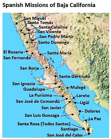
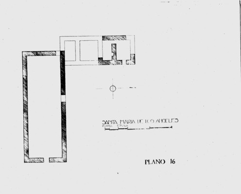
Full name: Santa María de los Angeles
Founding date: October 16, 1766 (relocated 30 miles northwest and renamed on May 26, 1767) Mission #17
Catholic Order: Jesuit
Founded by: Padre Victoriano Arnés, Padre Juan Diez (at Calamajué)
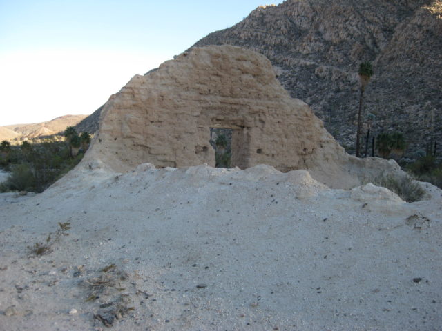
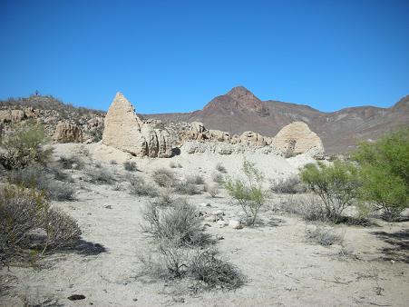
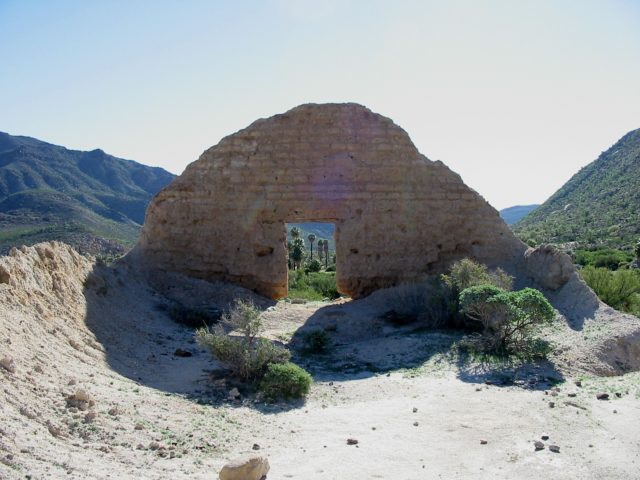
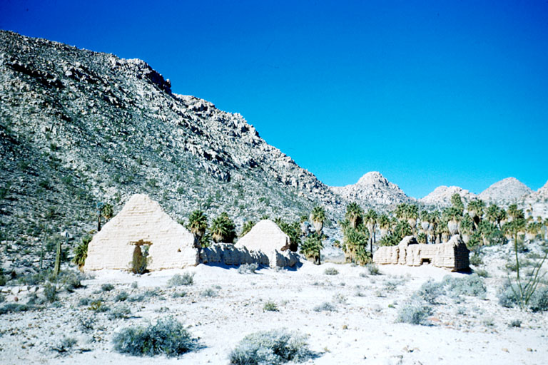
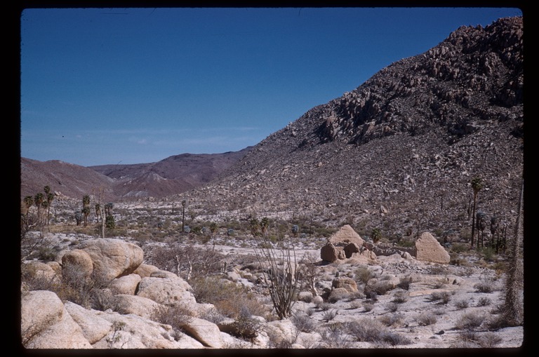
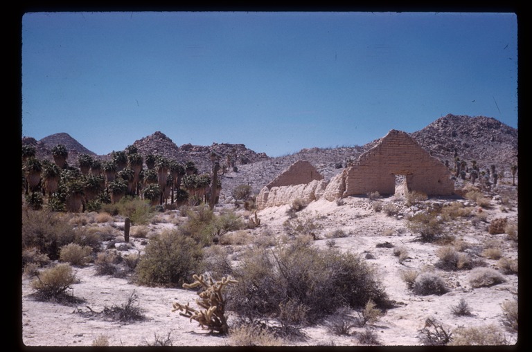
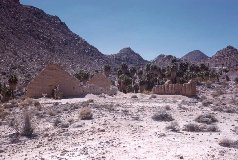
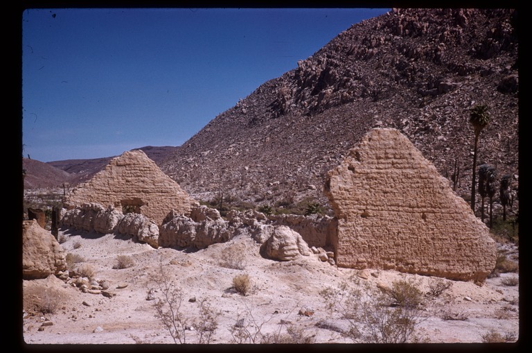
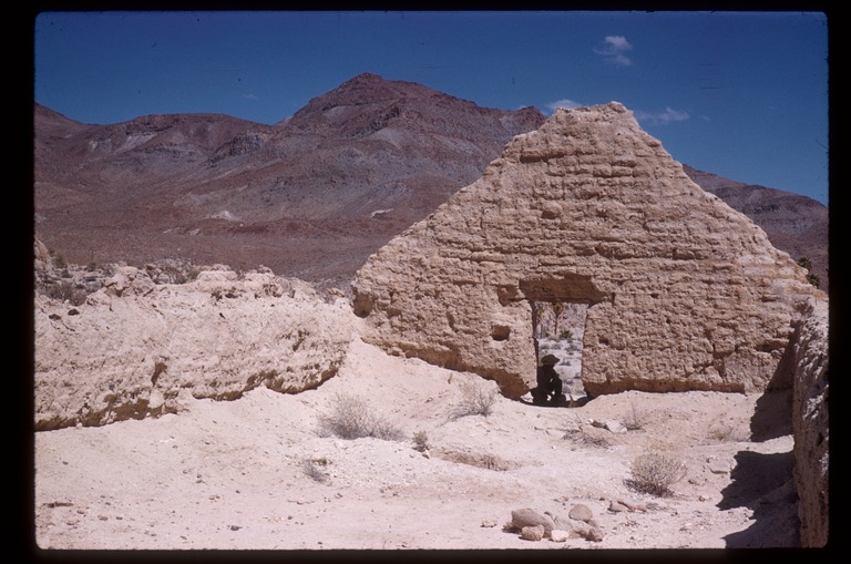
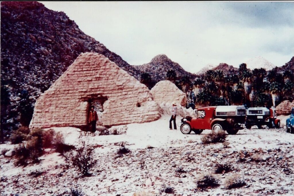
Condition: Adobe buildings at second site, built during Franciscan period in 1768-1769.
Closing date: Abandoned in 1774 or 1775.
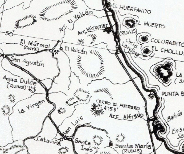
GPS/ Access: 29.731742, -114.547379 (second site/ Santa María), Mex. #1, Km. 181 (Santa Ynez), east 15 miles.
Read more: HERE
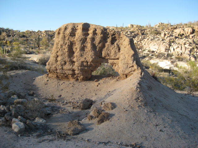
*The first location of this mission (1766-1767) was at Calamajué. See the Calamajué album: https://vivabaja.com/calamajue/
The following are my photos from five visits to Mission Santa María, from the photo albums of VivaBaja.com, showing the man-made artifacts from the 1700s (mainly in 1768 by the Franciscans who replaced the Jesuits in California. It was the Jesuits who founded this mission in October 1766 (at Calamajué) and moved it here in May 1767 for better water. The mission was abandoned by the Dominicans after the 1774 census. They replaced the Franciscans in Baja California, in 1773. Calamajué photos are in their own album, HERE.
>> To see where this mission is, maps and directions at bottom of page <<
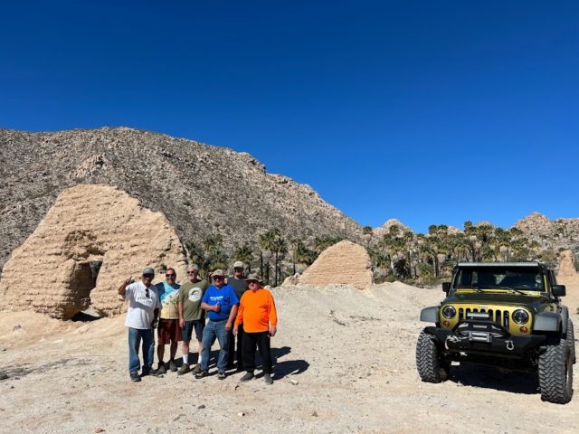
2022 photos by David Kier


The next morning:


2010 photos by David Kier

See all the 2010 trip photos: https://vivabaja.com/msm2010/


A Howard Gulick photo from the same location in 1961, to compare:

2007 photos by David Kier


See all the 2007 trip photos: https://vivabaja.com/msm/
2003 photos by David Kier:


2002 photos by Jack Swords:


1999 photos by David Kier:


Historic photos from others: oldest to 1960s
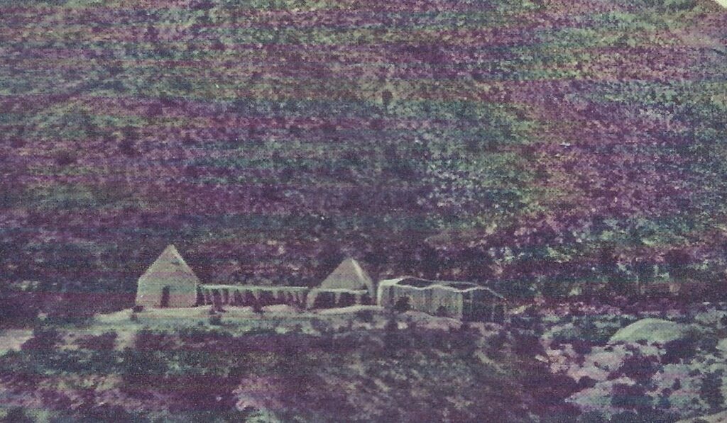
1961 Photos by Howard Gulick of the Lower California Guidebook
Regional Maps & INAH Plan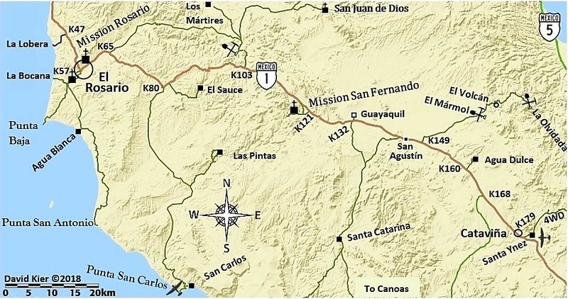

- GPS: 29.731742, -114.547379
- Directions: Highway #1, Km. 180.8 (south from San Quintín), then 15 miles east on an extremely difficult and potentially dangerous 4×4 trail!
- 2022 Trip Photo Album: https://vivabaja.com/msm2022/
- 2010 Trip Photo Album: https://vivabaja.com/msm2010/
- 2007 Trip Photo Album: https://vivabaja.com/msm/
- 2003 Trip Photo Album: https://vivabaja.com/p403/
- 1999 Trip Photo Album: https://vivabaja.com/missionsm/
Photos at the first location, known as Calamajué: https://vivabaja.com/calamajue/
I hope this was interesting or informative for you! Please be welcome to join our Baja California Land of Missions Book Group, on Facebook: HERE
- All the missions, quick look and history, north to south: HERE
- Other mission photo pages plus more Baja California history: HERE
- VivaBaja.com home page
The following chapter is from my book, Baja California Land of Missions Order your own copy from Amazon Books: HERE
#17 Nuestra Señora de Columna (Calamajué) /Santa María de los Ángeles (1766-1775)
The seventeenth Jesuit California mission was founded by Padre Victoriano Arnés and Padre Juan José Díez. The first mission location was at a site named Calagnujuet. The Cochimí name was soon modified to Calamajué (“Calah-mah-WAY”). Johann Jakob Baegert’s 1772 book, Observations in Lower California, provides the founding name of the mission as Nuestra Señora de Columna. “Columna” also appears on a map in the original German edition of Baegert’s book. Typically, this mission was called Calamajué. Some historians consider Calamajué as only a visita of Mission San Borja, but the documents show otherwise.
The running stream at Calamajué was discovered by Padre Fernando Consag in 1753 on his third expedition and revisited by Padre Wenceslaus Linck on April 12, 1766. During his 1766 expedition, Linck had discovered a fine site for a future mission far north at a location called Velicatá by the Cochimí Indians. The distance to Velicatá from Mission San Borja was too great through a potentially hostile region, and Calamajué was the only possible place for a mission known to the Jesuits between the two. Using funds provided by the Duquesa (Duchess) of Gandía, Doña María de Borja (of the famous Borgia family in Spain), the Jesuit Padre Visitador Lamberto Hostell, gave the order for a mission at Calamajué to be founded.
On October 16, 1766, Arnés and Díez arrived at the site after traveling for two days from San Borja with ten soldiers and fifty neophytes. The Calamajué site is on a shelf at the edge of a broad arroyo where a year-round stream emerges from a canyon. The water is heavily mineralized and undrinkable, although the local Cochimí natives were known to have survived on it. Wells had to be dug more than a mile away to provide potable water for the mission. The padres had hoped the minerals in the stream would serve as fertilizer for crops they would plant.
Soon construction of an adobe chapel, a storehouse, and residence for the missionaries was begun. Shacks were made for the soldiers’ quarters. Only one wooden door was available, and it was used to secure the storehouse. In the first months at the new mission, 200 Indians were baptized. Not long after the founding, Padre Díez became quite ill and returned to San Borja. Arnés continued on at Calamajué without Díez and soon had a confrontation with a tribe from a place called Cagnajuet, seventy miles to the north.
The men of Cagnajuet became angry when young women from their ranchería joined the mission. The men of Cagnajuet conspired with the Cochimí at Velicatá to kill the missionaries and soldiers. The Velicatá Cochimí had remembered the kindness of Padre Linck several months earlier and wanted no part in bringing harm to the Spanish. Juan Nepomuceno was the Cochimí neophyte governor at Calamajué. He sent six well-armed neophytes to Cagnajuet, captured the troublemakers, and brought them to the mission. Padre Arnés interceded and spared the prisoners from the lash, thus gaining their friendship and converting them to becoming Christians.
Wheat was planted, but when irrigated with the Arroyo Calamajué water, it withered and died. The soil became white with the salts from the stream. The mission could not survive any longer at Calamajué and seven months after Mission Nuestra Señora de Columna was founded, Padre Victoriano Arnés discovered a better location with good water. It was thirty miles away and called (in the Cochimí language) Cabujakaamang. There was not much arable land on which to cultivate crops, but the fine bay of San Luis Gonzaga was nearby, and it was reasoned that seafood could supplement their diet. Supplies from the south and mainland of Mexico could also be offloaded there.
The mission, relocated on May 26, 1767, to Cabujakaamang, was renamed Santa María de los Ángeles. When missions were moved, a complete name change was rare. This may have led to some confusion with writers about the relationship between Calamajué and Santa María. These both were indeed one mission, but two locations. The renamed and reestablished mission was to be a new start. What actually resulted would turn out to be the last mission center founded by the Jesuits. Orders for the Jesuits expulsion from the New World had already been made and were in route to Mexico from Spain during this period.
The new site had limited resources, but palms provided wood for building shacks that served as a chapel and residence for the missionary and his soldiers. Wheat and cotton were planted and in good condition when the expulsion orders arrived in January 1768. Santa María had 300 neophytes (baptized Indians) and thirty catechumens (Indians preparing for baptism) at the time of the expulsion.
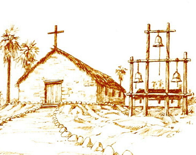
Almost four months had passed following the removal of the Jesuits before the Franciscans arrived to resume mission functions. Padre Juan Leon de Medina Beitia (also spelled Beytia or Veitia) arrived in May 1768. He saw that Santa María was lacking a suitable church, so he had one erected from adobe and roofed with tules (reeds). Next to it, a two-room adobe dwelling was constructed as well as a barn that served as a storage room.
After almost a year of isolation coupled with a lack of provisions here at Santa María, Padre Beitia removed himself to Mission San Ignacio by April 14, 1769. To fill the void at Santa María, San Borja’s Padre Fermin Francisco de Lausen, traveled to Santa María. Padre Andrés Villumbrales had been assigned to Mission San Luis Gonzaga, but when it was closed, he was sent to San Borja to assist Lausen who was dividing his time between two missions.
California Franciscan President Junípero Serra, during his expedition to Alta California, was at Santa María from May 5 to May 11, 1769. Serra examined the lonely mission and found it had potential greater than the reports he had read. Serra’s opinion to further develop Santa María changed, however, after he arrived at Velicatá, three days later. It was on May 14, 1769, that Serra founded Mission San Fernando at Velicatá.
Serra had a cargo trail constructed from San Luis Gonzaga Bay to San Fernando, passing just north of Santa María’s valley. The Camino Real route was also improved between Calamajué and Santa María by moving it from the bottom of the deep canyon, east of the mission, and placing it on top of the north rim of the canyon.
The highest population recorded at Mission Santa María was 523 in September 1771. Five families and four single young men lived at the mission center and the others lived in various rancherías surrounding the mission. In a report from February 12, 1772, Padre Francisco Palóu states that Mission Santa María loaned one of its bells to Mission San Fernando de Velicatá to serve that new mission’s needs. In 1772, an unnamed epidemic caused the population to drop, and just 317 neophytes were living in the Santa María territory in 1773. In 1774, a final census at Mission Santa María recorded 485 neophytes. By 1775 the mission’s neophytes were relocated to Mission San Fernando and Santa María became just an outpost on El Camino Real.
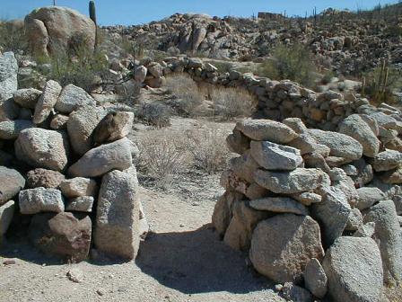
At the first mission site (Calamajué) only the outlines of the adobe walled church and other buildings remain today. Calamajué is accessed on a dirt road, east and then south thirteen miles from Coco’s Corner (a road junction located off Highway Five, thirteen miles north of Laguna Chapala and twenty-three miles south of Bahía San Luis Gonzaga).
The adobe ruins at Santa María are most impressive, perhaps because of its remoteness and dry climate. The 14.5 mile “extreme” dirt road to Santa María begins at Rancho Santa Ynez (just south of Cataviña, off Highway One, Km 181) and is known as one of the roughest four-wheel drive trails in Baja California. Less than two miles from the mission is a steep, rocky grade known as the “widowmaker” followed by a swamp with water levels sometimes two feet deep referred to as the “bog”. The mission is just over a ridge from the bog. The final half mile has steep gullies as a final barrier to many vehicles.
Missionaries recorded at Calamajué/Santa María:
Jesuit
Juan Díez 1766
Victoriano Arnés 1766-1768
(Mission moved and renamed in 1767)
Franciscan
Juan de Medina Beitia April 5, 1768
Francisco de Lasuén 1769 (from San Borja)
Miguél de la Campa y Cos 1769-1773 (from San Fernando)
Antonio Linares 1771 (from San Fernando)
Vicente Fuster 1771-1773 (from San Fernando)
Dominican
Miguel Hidalgo (to 1774) and Pedro Gandiága (to 1774) May 15, 1773
See the first location for this mission, at Calamajué: https://vivabaja.com/calamajue/
See the other mission pages: https://vivabaja.com/baja-mission-albums/