The Rock Trail 9/2005
by Kevin Ward (Baja Racer and Dust to Glory producer)
It was a perfect late October morning in Alfonsina’s. I woke up early enough to watch one of those epic sunrises, just a murmuring of activity, and listened to the lapping of the water on the sand. We got Antonio and Irma up (earlier than they wanted I think), and had one of their classic breakfasts. I sat around the table with 5 of my good friends. We had just completed two fantastic days of riding…
We had launched out of Ensenada early on day one, hammered the pavement to Ojos, and rode that classic piece of Baja to Tres Hermanos and out to Uruapan. We ate breakfast at the Palomar in Santo Tomas, and then rode the Pacific all the way to San Quintin (if you stick with it all the way, there are some great downhill waterfall washes that drop you off the mesas and back down on the sand just before San Quintin). We then rode the pavement to El Rosario, gorged at Mama Espinoza’s, and laid ourselves down for the night.
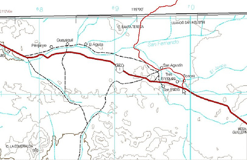
Day two we rode south out of El Rosario to end up at San Carlos on the beach. From there followed some two track southeast that then turns into some first class single-track up and over the Mesa Santa Catarina, and through the Agua Amarga canyon, and then running pretty much “cross grain” on single track and two track all the way into Cataviña. At lunch in Cataviña I tried to convince my companions to ride this trail I had heard of that goes from Cataviña to Puertecitos. No luck………turned out to be a good thing though. Even taking the shortcut at Pedregoso (Las Turquesa Canyon) that puts you on the main road just above Coco’s, it was dark by the time we got to Gonzaga Bay. Which takes us to where I started this story……… breakfast at Alfonsina’s.
Once again I tried to lean on my buddies, trying every tactic in the book, to go try that trail with me. Nope……….they were going to cruise up to San Felipe, eat some fish tacos, and be back in E town by dark. So I said “screw it” and gathered up all the spare XR 650 parts from my buddies I was wiling to carry, and headed south with a handful of GPS waypoints and an empty Clorox bottle slapping my hip. I took the Turquesa Canyon shortcut “uphill” back to Cataviña (not an easy feat mind you “uphill”- definitely a challenge!) and was in Cataviña by 9am. I filled up my camelback, my 4gal tank, and my Clorox bottle. Just north of Cataviña a few clicks, hang a right, and then parallel the highway north, and you are riding classic Baja two track. I hauled ass for quite a while, just setting it into berm after sandy berm. The roads then join the original Hwy 1, which is a pretty rocky nasty stretch all the way out to El Mármol, kind of a forgotten little town. After El Mármol, I continued north/ northwest to a waypoint at a ranch, keeping some low mountains on my right.
Hah!! I’d gone the magical 25 miles, and I stopped and got that confounded gallon of gas off my hip and into my tank! I took a break and assessed the day. It was still early, only 10:30, and it was going to be a nice cool day. I ate a Cliff bar and some of my favorite beef jerky from the Sanchez market in San Quintin. It was definitely time to change my riding style. It was time to slow down, be cool, and take absolutely no chances. The enormity of my decision was starting to weigh on me. I had no Sat phone. None of my friends had the waypoints I was following, or even knew the name of the crazy girl that had given them to me. Sure I was as seasoned of a Baja rider there was.
I’d spent a day making proper length spokes for my XR out of two wheels off of an old CL70 at a locals house in Scorpion Bay after I’d completely blown my rear wheel out just north of San Juanico. I’ve hiked 4 miles in my Alpine Stars to buy a half gallon of drain oil and a bolt from a rancher that I could crossthread into the drain hole in my case. I’ve taken my carburetor completely apart with a Leatherman on my lap and used a cactus spine to poke the holes clean in the estachion tube. But this was different. I was truly heading into no man’s land. Look at any map, it is a very desolate area.
I continued chasing waypoints north on faint two tracks, the occasional ranch now being uninhabited. I connected a few old mine roads, and then just as I’d imagined, a waypoint finally turned me Northeast into one of the many creek beds I had been crossing. There was no more two track now, no more single-track, just a virgin riverbed. I followed that for a few more miles, and it began to climb at an alarming rate. Just when it was time to start trials riding up solid rock waterfalls, a waypoint directed me to bail out to the left.
I stopped, took a breather, took a leak, took a look around, and assessed things again. My 15 tooth countershaft sprocket coupled with a 47 tooth rear was ridiculously tall for what I was doing. I hadn’t had to use the clutch yet though, and it was only noon……….press on. Now I would get the occasional glimpse of the single-track. Some of it was very committing……with steep faces and sustained big rocks that had to be charged- no picking your way up those. I started to think about the guy that put this route in- Bill Nichols. He must have had one hell of a bug up his ass! To pioneer a route of this magnitude, from Cataviña (nowhere) to Puertecitos (nowhere)- something that apparently took him years and years to complete! I heard he overflew the route (in progress) in a small Cessna dozens of times to find the way through some of the highly technical sections.
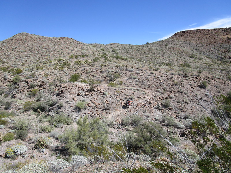
I started gaining a lot of altitude- the Sierra Santa Isabel range it said on my map. The trail became rockier and rockier and rockier. Where waypoints made no sense, Bill had painted white dots on rocks. If I maintained about 12-15 mph, I sorted of stayed on top of the rocks. Any slower, and you would simply come to a stop against a big rock. I started to feel like one of those guys in the Erzburg rally. The faint trail would come and go, waypoints would save me occasionally.
I finally found myself on a huge high altitude mesa, with the rocks only about bowling ball sized, I stopped and took a break. At this point I realized there was no way Bill wore a helmet when he put this trail in. No way. I had a vision of him wearing some hiking boots, cargo pants, backpack and a big wide sombrero with some wraparound shades. Maybe a cigarette hanging out of his mouth.
The view was stupendous in all directions, and the isolation was complete. In all of my travels in Baja, I have never felt so completely removed and isolated. I walked and inspected the trail carefully. It seemed maybe 5 bikes had been through here in the last year. Maybe Bill had rode it 10 or 15 times while he built it. Maybe 30 bikes total since he put it in.
The rock torture continued, but I hadn’t fallen yet, and was pretty proud of myself. Of course one fall could also end it all. Break an ankle this could turn into a miserable time, or worse yet have a rib puncture a lung and I would be a goner. No mistakes allowed. The trail smoothed out a bit, turning into slabs of rock, as opposed to piles of rock. Ahead loomed a crevasse, a canyon, an immense gap in the mesa. I ventured a look around- I was heading right for the edge and my next waypoint put me straight ahead! Was this some kind of cruel joke? Had there been a massive undocumented earthquake that had split the trail?
I rode right up to the edge and looked out over the expanse. Unbelievable…………..he had stacked rocks straight down the face of the cliff under me in a series of switchbacks that led all the way down onto another mesa several hundred feet below. Add a big digging bar and a shovel to his backpack! There was evidence of a bit of a camp at the top. A fire ring, a cleared area for a tent. He had camped here and toiled away on this cliff face to create the trail!
Down I went. The switchbacks were all doable without getting off the bike. Just amazing. A few more miles and a few more waypoints led me to a steep downhill sand wash. As I started to smell the ocean, I relaxed and picked my speed back up. A few more miles found me coming into the top of some mining activity, and soon after I hit the dirt road a few miles south of Puertecitos. I had plenty of fuel to get to San Felipe, and caught up with my buddies for a late lunch just as they were ordering a second round of beers and tacos on the Melancon.
Having ridden the “Rock Trail” solo I am in no position to recommend against it………but I must say it is a commitment. If any of you reading this are rock climbers…..it’s kind of like leading a sustained runout thin 5.11+ crack somewhere way up on a granite wall. The vulnerability and exposure make you feel more alive than anything else, but there is a bit of risk.
To do it with a group would be miserable. Flat tires and bent shifters and broken levers would pretty much be the theme of the day. To do it with a couple of friends who are strong riders would be a gas. I highly recommend it.
Kevin Ward

On Google Earth:
