EL DESCANSO 32°12’19.62″ -116°54’19.24″ Located behind a church that can be seen from the Ensenada toll road. An exit just north once was signed for the mission, but has been renamed ‘Rancho Descanso’. Access from the free road along the lagoon/ arroyo, under the toll road bridge (south of the Cantamar sand dunes). The original site (1810-1830) and fort location (Descanso-1/Fort) is to the south of the arroyo, on the hill: 32°11’59.40″, -116°54’30.00″

SAN MIGUEL 32°05’39.10″, -116°51’15.03″ Located right on the free road in La Mision, next to a school on the north side of the road.

GUADALUPE 32°05’31.0″, -116°34’27.3″ Located on a dirt street 1/4 mi. east of the entrance paved road going through Guadalupe, 0.8 mi. from Highway 3.

SANTA CATALINA 31°39’38.10″,-115°49’16.00″ Located on a hilltop overlooking a cemetery on the far side of the community of Santa Catarina, east of Ejido Independencia off Hwy. 3.

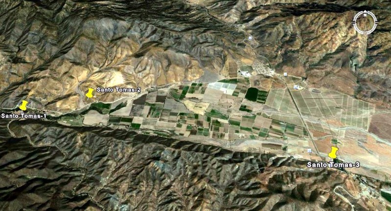
SANTO TOMAS-1 31°34’11.00″ -116°28’50.00″ Located by an oak grove picnic and camping area off the road to La Bocana, 3.9 miles from Hwy. 1. SANTO TOMAS-2 31°34’24.30″ -116°27’58.70″ Located north of the La Bocana road in a pepper field, 2.8 miles from Hwy. 1. SANTO TOMAS-3 31°33’30.00″ -116°24’48.90″ Located next to the El Palomar campground on Hwy. 1.
SAN VICENTE 31°19’47.90″ -116°15’33.00″ Located a short drive west of Hwy. 1, north of San Vicente. Well signed.

SAN PEDRO MÁRTIR 30°47’24.25″ -115°28’20.85″ Located over 5,000 feet above sea level and requires 2 days of backpacking to reach. The first location (Casilepe): 30°53’45.5″ -115°28’08.6″ at 6,800 feet was abandoned after just 3 months.

(Visita) SAN ISIDORO 30°45’55.17″ -115°32’49.81″ Located on the trail to Misión San Pedro Mártir.

SANTO DOMINGO 30°46’15.20″ -115°56’14.00″ Located 5 miles east of Hwy. 1, just north of the Arroyo Santo Domingo bridge, north of Colonia Vicente Guerrero. Signed.

ROSARIO-1 30°04’01.00″ -115°43’08.00″ Located just off Hwy. 1 in El Rosario. Signed. ROSARIO-2 30°02’29.00″ -115°44’20.80″ Located in the town of Rosario de Abajo, just over a mile from Hwy. 1.

SAN FERNANDO VELICATA 29°58’16.52″ -115°14’12.20″ Located just over 2 miles from Hwy. 1. Signed turnoff by Km. 121, Rancho Progreso. A locked gate is mid-way in to the site. Obtain key from ranch.

(Visita) SAN JUAN DE DIOS 30°10’57.61″ -115°10’04.50″ Located just past Rancho Las Palmas and above the east side of the arroyo, next to the road to Rancho El Metate, 22 miles from Hwy. 1.

(note: site obliterated by farmer in 2006)
(Historic spring on El Camino Real) AGUA DULCE 29°52’58.70″ -114°49’25.00″ Located 2 miles east from Hwy. 1 at Km. 160-161.

SANTA MARÍA 29°43’54.50″ -114°32’50.16″ Located 14.5 miles from Rancho Santa Ynez over an extreme 4WD road.

CALAMAJUÉ 29°25’16.30″ -114°11’42.36″ Located 15.5 miles north of Hwy. 1 (Km. 261) or 18 miles southeast of Coco’s Corner (Hwy. 5, Km. 179.5), on the east bank of Arroyo Calamajué.

(Historic water hole near El Camino Real) TINAJA DE YUBAY 29°10’41.37″ -113°59’15.20″ Located north of the L.A. Bay highway off the road signed ‘Rancho San Luis’.

SAN BORJA 28°44’40.37″ -113°45’14.39″ Well signed 21 miles south of L.A. Bay highway or east of Hwy. 1 at Nuevo Rosarito.

(Visita) SANTA ANA 28°41’25.23″ -113°49’14.31″ Located south of the San Borja/ Nuevo Rosarito road.

(Water hole near Golfo Camino Real) TINAJA DE SANTA MARIA 28°26’05.20″ -113°20’01.40″ Located south from the old road to San Francisquito, south of Bahia de los Angeles and just east of Rancho La Bocana (San Pedro).

SANTA GERTRUDIS 28°03’04.02″ -113°05’07.17″ Access roads from El Arco, Guillermo Prieto and San Francisquito/ El Barril.

(Visita) S AN PABLO 27°42’07.81″ -113°08’42.08″ Located in San Pablo Canyon, east of Vizcaino. Access is behind a locked gate, 8 miles from the visita. Obtain a guide in Vizcaino (Junior’s Auto Shop).

SAN IGNACIO 27°17’02.18″ -112°53’56.12″ Facing the town plaza of San Ignacio.

GUADALUPE 26°55’06.3″N 112°24’20.8″W Signed as the ‘ex-misión’ of Guadalupe, southeast of San Jose de Magdalena and northwest of Mulegé.

SANTA ROSALIA DE MULEGÉ 26°05’37.00″ -111°59’09.30″ On the south side of the river, just west of the highway bridge in Mulegé.

SAN JOSE DE MAGDALENA 27°03’40.33″ 112°13’24.87″ An old church ruin from after the mission period is just east of the town, on the south side of the arroyo, north of Mulegé.

(Pila/ ag site for San Jose de Magdalena, mis-identified as Misión Santa Maria Magdalena) 27°03’29.10″ -112°10’12.34″ Located just outside the canyon ‘Boca de Magdalena’ east of Palo Verde, north of Mulegé. The stone building ruins were on both sides of the road at 27°03’29.90″ -112°10’07.40″, 4.6 miles from Hwy. 1 at Km.162.5 (take left road at mile 3.7). Ruins destroyed by flash flood in 2014. Pila was partially destroyed in 2014 and may be erased since.


SAN JOSE DE COMONDÚ (1st site, ‘Comondú Viejo’) 26°16’27.40″ -111°43’08.50″ On the old transpeninsular road between ranchos of San Juan and La Presa. 11 miles west of hwy. 1 on the La Purisima road (south of Bahia Concepcion), turn south for 9 miles. 22 miles north of town of Comondú.

SAN JOSE DE COMONDÚ (final site) 26°03’34.59″ -111°49’20.41″ In the town of San Jose Comondú.

LA PURÍSIMA (Ruins of ‘Purísima Vieja’) 26°18’34.48″ -112°09’50.98″ Located 16 miles north of San Isidro, 3.4 miles south of Paso Hondo. Some say the first mission site.

LA PURÍSIMA (final site) 26°11’25.60″ -112°04’22.60″ In the town of La Purísima.

SAN BRUNO (1683-1685 colony site) 26°13’57.50″ -111°23’53.90″ 14 miles north of Loreto near, the coast on a hill.

LORETO 26°00’37.00″ -111°20’35.80″ In the center of town.

(Visita) SAN JUAN BAUTISTA LONDO 26°13’30.83″ -111°28’24.51″ About 17 miles north of Loreto and just west of Hwy. 1, next to a ranch. Ruins visible from the highway.

SAN JAVIER 25°51’36.86″ -111°32’36.99″ 22 miles west and south from Loreto, well signed.

(Visita) LA PRESENTACIÓN 25°43’45.00″ -111°32’37.40″ About 11 miles south of San Javier.

SAN JUAN BAUTISTA DE LIGÜÍ/ DE MALIBAT 25°44’22.20″ -111°15’51.00″ (no remains, arroyo swallowed ruins in 2001) At the southeast junction of the road to Playa Ligüí and Ensenada Blanca, just east of Hwy. 1, nine miles south of Puerto Escondido.

LOS DOLORES APATÉ 25°03’19.04″ -110°53’03.33″ Access by foot/ mule trail off road to Los Burros about 15 miles northeast of La Presa and Los Dolores Chillá (La Pasión).

LOS DOLORES CHILLÁ (La Pasión) 24°53’14.4″ -111°01’49.81″ Just east of Rancho La Presa at Rancho La Capilla just off the road to Santa María de los Toris and Los Burros.

SAN LUIS GONZAGA 24°54’29.00″ -111°17’27.25″ Off the road to Presa el Ihuajal, 10 miles south of Ciudad Constitución.

EL NOVILLO 23°55’48.60″ -110°13’28.20″ (and old church ruin, likely post-mission… Pin location and GPS from Jack Swords)

(Visita) ANGEL DE LA GUARDA (EL ZALATO) 23°53’27.60″ -110°10’14.80″ (a visita of the La Paz mission)

SAN BLAS (a church from the 1760’s) down the hill from El Zalato 23°53’10.40″ -110°09’16.21″

(view sideways and looking west)
TODOS SANTOS: There are two missions and two mission sites at Todos Santos. The first site began as a visita for the La Paz mission (named ‘Todos Santos’), then became a separate mission named ‘Santa Rosa de las Palmas’… some stone foundations are all that remain across from a modern church is built on the site: 23°27’37.30″ -110°13’08.31″]. The La Paz mission (Nuestra Señora del Pilar de la Paz) moved from the Bay of La Paz to Todos Santos and that ended the Santa Rosa mission… The second site is the location of the modern town church of Todos Santos, where the mission moved. 23°26’59.16″ -110°13’31.62″

(Visita) SAN JACINTO 23°14’34.21″ -110°04’37.20″

The original mission ruins for La Paz, Santiago and San Jose del Cabo are not visible or have been built over by newer construction. The modern town church for Todos Santos, Santiago and San Jose del Cabo are built on mission locations. A plaque marks the possible first location for the La Paz mission. Details on the Baja missions: http://vivabaja.com/missions1
LA PAZ (plaque) 24°09’36.00″ -110°18’59.40″
SANTIAGO 23°28’32.50″ -109°43’02.40″
SAN JOSÉ DEL CABO 23°03’43.70″ -109°41’44.30″