A kilometer is equal to 0.62 of a mile (100 kms. = 62 miles). U.S. sold vehicle odometers use miles. Here, three modifiers help find points between posted kilometers: + is about 1/4 kilometer from the marker figure (~0.1-0.2 mile); .5 is about 1/2 km. from the marker (~0.3 mile); .5+ is about 3/4 km. from the figure (~0.4-0.5 mile). Some Pemex brand gas stations are now different brands (ARCO, Chevron, BP, etc.).
The 2021 & 2023 Benchmark Baja California Road & Recreation Atlas (as well as the Avenza Benchmark App) has all the kilometer points on their map pages.
For travel south of Tijuana: Soon after leaving border inspection area, take the route signed for Playas/ Rosarito/ Ensenada, also called the “Scenic Road” (Hwy. 1-D, a toll road) to KM 34.5 (south side of Rosarito), then exit onto Free Road (to visit points of interest). *See below if remaining on toll road south of Rosarito.
KM 28 marker on free road, south Rosarito. (Free road kilometer distance, from Tijuana, are less than toll road)
KM 33+ Corridor 2000 (BC #201) to Otay Border or Tecate highway.
KM 44.5 Pemex/ Puerto Nuevo
KM 47 Cantamar, sand dunes just south of town.
KM 49+ Road east to El Descanso, a mission from 1830 behind the church, 1/2 mile.
KM 52.5 Splash and just south is the Half Way House (restaurants).
KM 65.5 La Misión and 1788 site of Mission San Miguel.
KM 83 Paved road east to Valle de Guadalupe.
KM 95.5 Junction with Toll Road (Hwy. 1-D, KM 99.5).
*If remaining on toll road, south of Rosarito:
Hwy. 1-D: KM 74 La Salina Marina, old road to La Misión.
Hwy. 1-D: KM 78 Bajamar
Hwy. 1-D: KM 84 Overlook, El Mirador
Hwy. 1-D: KM 93 Salsipuedes
Hwy. 1-D: KM 99 Last Toll Gate, San Miguel Village
Hwy. 1-D: KM 99.5 Junction with free road, Highway 1.
KM 101.5 Jcn. with Hwy 3 from Tecate
KM 107.5 Fork in highway, take right branch along coast.
KM 110+ Ensenada harbor
Reset Kilometer to 0 at Ensenada:
KM 21+ La Bufadora/ Punta Banda highway junction, west
KM 31 Las Cañadas campground/ waterpark
KM 37.5 Military Checkpoint
KM 40.5 Acambaro, market and restaurant. Rancho La Grulla.
KM 41.5 Ejido Uruapan road east
KM 47 Puerto Santo Tomás & La Bocana road west
KM 50 Santo Tomás/ El Palomar RV Park (closed in 2025)
KM 79 Paved road to Ejido Erendira
KM 88.5 Mission San Vicente road west.
KM 90 San Vicente (Pemex)
KM 102.5+ Graded road to Valle de Trinidad, 40 mi.
KM 120 Location where southbound pavement terminated, from 1951 to 1968.
KM 128 Colonet
KM 131 Hotel Paraiso Colonet
KM 140.5 Paved road to Meling Ranch, National Park, and Observatory
KM 149.5 Punta San Jacinto road west, Albertino mine road east
KM 157 Camalu
KM 169+ Access to Bahia San Ramon, west/ Mission Santo Domingo Rd. east
KM 189 Restaurant Misión Santa Isabel
KM 191/192 Several Hotels both sides.
On the Observatory Road (Km. 140.5):
- KM 7 One-lane-wide bridge
- KM 9+ San Telmo (de Arriba)
- KM 18 Hacienda Sinaloa
- KM 27.5 Road south to Valladares, El Potrero
- KM 28.5 Road north to Las Choyas, El Cortez, El Papalote
- Km 49 Road north to El Coyote Guest Ranch (4.9 miles)
- KM 49.5 Road right, downhill to Rancho Meling (0.9 mile)
- KM 63.5+ Road south to El Potrero
- KM 66 Socorro Mine
- KM 67 Road north to La Joya, La Concepción (formerly Baja Dark Skies Inn)
- KM 73.5+ Road south to Los Manzanos (0.3 mile)
- KM 74.5+ Road north to La Cienega de Soto
- KM 77.5 Former park entrance ranger station, elev. 7,000 ft.
- KM 83.5 San Pedro Mártir Park entrance, ranger station, elev. 8,000 ft.
- KM 86.5 Capilla San Pedro chapel
- KM 91 Road south to La Tesajera (6.2 miles). Locked gate in 1.9 miles.
- KM 91.5+ Park Museum
- KM 93+ Road south to Aguaje del Burro (2.0 miles)
- KM 93.5+ Road south to Mirador El Altar and beyond
- KM 97.5 Observatory Complex Gate (elev. 8,700 ft.) open 10 am-1 pm
- KM 100+ Observatory, 84 inch mirror (elev. 9,280 ft.)
Reset Kilometer 196/0, South of San Quintin:
KM 1 Old Mill, Don Eddie’s, Campo Lorenzo paved road west
KM 1.5 Los Olivos RV Park, Baja Jardines (motel and restaurant) west.
KM 3 Old Pier
KM 11 Los Pinos Pemex, paved road west to Hotel Misión Santa María and Motel Cielito Lindo
KM 16 El Pabellon RV Park
KM 16+ Parcela 12 (restaurant)
KM 16.5 Fidel’s El Pabellon RV Park
KM 25.5 Playa El Socorro
KM 47.5 La Lobera road (3 mi)
KM 57 El Rosario Pemex ‘Baja Cactus’ (motel next door)
KM 57.5 (at sharp curve) Jcn. El Rosario de Abajo, Punta Baja road right.
KM 58 El Rosario Plaza/Police Station
KM 58.5 Mission El Rosario ruins, uphill north on concrete street
KM 59 Loncheria El Faro restaurant
KM 59.5 Restaurant La Pasadita
Km 60.5 Turista Motel, Baja’s Best B&B El Rosario
KM 80 & 81 Access to Punta San Carlos, Las Pintas fossil grotto.
KM 82 Road right to Rancho El Sauce camping and cabins (10 kms.)
KM 103+ Restaurant Sacrificio. Road north to San Juan de Dios, Los Mártires, etc.
KM 108+ Loncheria El Descanso
KM 116.5 Hector’s Monument
KM 121+ El Progreso ruin/ Mission San Fernando road (2.6 mi)
KM 129 Café La Pasadita
KM 131 Rancho Las Cuates (tire repair)
KM 132+ Road to Puerto Santa Catarina (37 mi) & Canoas (44 mi)
KM 132.5 Guayaquil road (an abandoned town, 1/2 mile north)
KM 145 San Agustin, abandoned gas station and RV park.
KM 149 El Mármol access (9.3 miles) and Arroyo El Volcán (13.3 mi)
KM 149.5 Sonora Café, onyx curios (closed in June 2017)
KM 160.5+ Agua Dulce access, (2 miles): Turn left at 1.4 mi., go 0.3 mi. then turn right for 0.3 more. Ranch now on site.
KM 168 Access to Pacific Coast & San Telmo Onyx mine, mine turnoff left at 10.7 mi.
KM 171 Giant Boulder, blasted for 1973 highway construction.
KM 176 Rock Art parking
KM 179-180 Cataviña
KM 180.5+ Rancho Santa Ynez (1 km)
KM 191.5 Monument to 1973 Highway Crews, Restaurant San Ignacito
KM 196 Rancho San Martin.
KM 210 El Pedregoso Rock mtn west side
KM 213 Access east to Turquesa Canyon Grade
KM 233+ Jcn. Hwy 5 from Gonzaga Bay (31 mi) and San Felipe (130 mi).
KM 234 Laguna Chapala. Access west to Pacific Ocean at Playa Christie. 4WD only.
KM 251 Access to Mission Calamajué (left in 5.4 mi., 13.8 to mission)
KM 252 Access to Pacific at Bahia Blanco, very rough 4WD only.
KM 261 El Crucero, Calamajué Canyon road (15.3 miles to mission, 50.3 mi. to Gonzaga Bay)
KM 270 Roads: SE to El Desengaño gold mine, NE to Rancho San Luis.
KM 270.5 4×4 Access to Pacific Ocean joins Rd from KM252 in 9.3 miles.
KM 282/0 Jcn. Hwy to Bahía de los Angeles (L.A. Bay)
On L.A. Bay Hwy (some maps show as Mexico #12):
KM 11.5+ Road north to El Desengaño and Tinaja de Yubay.
KM 18 Road north to Luz de Mexico gold mine.
KM 38.5 Road north to Bahía Guadalupe/Remedios and Los Candeleros.
KM 45 San Borja access
KM 65 Pemex Gas Station
KM 66 L.A. Bay/ La Gringa Road Jcn.
South from Bahía de los Angeles, unpaved:
KM 0 is 1/2 kilometer south of the pavement end (Xitlali Market)
KM 6 Camp Gecko road east
KM 7 Road east to other side of bay
KM 15 Las Flores site, to the west
KM 19 Poor Road ahead to terminal platform, end of railroad. Main road curves left.
KM 34.5 Old road south
KM 41 Road north to Bahía Las Animas
KM 68 Beach access
KM 71.5 Bahía San Rafael, camp road.
KM 89 Old road north
KM 95.5 Steep Grade
KM 107.5+ Left Turn at crossroad
KM 110 Junction with El Arco/ San Francisquito road
On Hwy. 1, at L.A. Bay Jcn.: Reset Kilometer to 282/0:
KM 13.5 Punta Prieta town entrance road
KM 38.5 Hwy to Santa Rosalillita
KM 52 Nuevo Rosarito village and access to Mission San Borja
KM 54.5 Restaurant La Cienega
KM 62.5 Access to Pacific Ocean by Altamira, Punta Rosarito.
KM 69 Military Checkpoint. Access to El Tomatal and Campo Esmeralda
KM 70 Access east to El Marmolito, onyx mine
KM 95 Villa Jesus Maria (new signs “Valle Jesus María” in error)
KM 95.5 Hotel Villa del Mar
KM 96 Laguna Manuela access (take dirt road left after 0.8 mi)
KM 121.5 Road west to sand dune field, 0.5 mi.
KM 123 Road east to pronghorn reserve, 1.6 mi.
KM 124.5 Paved road west to airport and dirt road on into Guerrero Negro.
KM 127 Eagle Monument, State border, Mountain time zone.
Reset Kilometer to 127/220 at Eagle Monument. Note: KMs get smaller going south, now in Baja Ca Sur:
KM 220 Eagle Monument, State Border, Time Zone change
KM 219 Agricultural inspection/ spray.
KM 216/217 Guerrero Negro paved road west junction
KM 207.5 Access west to whale watching
KM 189 Jcn. with road to El Arco and Punta San Francisquito
KM 154.5 Road NE to Guillermo Prieto/ Santa Gertrudis/ San Francisquito
KM 144 Vizcaino
KM 133 Access to old Baja 1000 course east side northbound
KM 124 Microwave tower Los Angeles
KM 117+ Jcn. Road to San Francisco de la Sierra
KM 97+ Jcn. Hwy to Punta Abreojos & La Bocana
KM 88 Microwave tower Abulon
KM 77 Military Checkpoint
KM 73 San Ignacio
KM 52+ Santa Marta road
KM 35 Microwave tower Caguama
KM 31.5 Jcn. Hotel & Geo plant Tres Virgenes
KM 17/18 Microwave tower Almeja
KM 0 Santa Rosalia
Reset Kilometer to 0/195 at Santa Rosalia:
KM 189/190 Prison
KM 188 Santa Agueda access
KM 181.5 San Lucas RV Park, Bahía Restaurant (0.5 mile)
KM 178 Playa Dos Amigos camping (0.6 mile)
KM 180 Microwave tower San Lucas
KM 168+ San Jose de Magdalena access
KM 162+ Boca de Magdalena access
KM 156 San Borjitas Cave access (18 miles)
KM 155.5 Palo Verde/ Punta Chivato access
KM 150+ Playa Santa Inés road
KM 135+ Mulegé entrance street
KM 134 paved road to Mission Santa Rosalia de Mulegé
KM 130 South Mulegé Pemex
KM 118+ Playa Frambes Resort access
KM 114 Playa Santispac
KM 111+ Playa La Escondida
KM 110.5 Los Cocos
KM 108.5 Playa El Burro
KM 107 Playa El Coyote
KM 93+ Playa Buenaventura
KM 92 Playa El Requesón/ La Perla
KM 90+ Playa Armenta
KM 74 Access to east side of Bahia Concepcion.
KM 62 Rosarito, San Nicolas road
KM 59+ Jcn. road west to San Isidro and La Purisima
KM 48.5 San Juanico & San Basilio public road.
KM 40 San Basilio private road.
KM 30 San Juan Bautista Londó access
KM 26+ San Bruno area access.
KM 24 Military Checkpoint.
KM 0 Loreto
Reset Kilometer to 0/119 at Loreto:
KM 117+ San Javier Hwy.
KM 103 Restaurant Vista del Mar/ Playa Notri
KM 99.5 View parking
KM 97.5 Juncalito village road
KM 97 Beach access
KM 94 Puerto Escondido
KM 84+ Ligüí village, beach access.
KM 83 Danzante Bay Resort road
KM 63.5 Jcn. Road to Agua Verde (paved for 10 kms.)
KM 0 Ciudad Insurgentes, left turn for south
Reset Kilometer to 0/237 at the turn, in Insurgentes:
KM 211.5 Paved road west to Puerto San Carlos (57 kms.)
KM 210 Ciudad Constitución
KM 195 Jcn. Graded road east to Mission San Luis Gonzaga (22 miles)
KM 180 Access road west to Puerto Cancun
KM 173 Graded road west to Puerto Cancun
KM 157 Santa Rita and graded road west to Puerto Chale
KM 154 Road east to San Andres and beyond
KM 127.5 Graded road northeast towards San Luis Gonzaga/ La Presa
KM 112.5 Las Pocitas, road east to La Soledad and San Evaristo
KM 110.5 Road west to Rancho Santa Fe
KM 79.5 Road west to Punta Conejo (9.4 miles)
KM 60 Microwave tower el Cardón
KM 55.5 Road west to La Aguja (14 miles)
KM 38+ Paved road to Ejido Conquista (18 miles) and Punta Marquez (4.7 additional, unpaved miles)
KM 21 Federal Police Checkpoint
KM 17 Paved road north to San Juan de la Costa, dirt road beyond to San Evaristo
KM 8 Dove Monument, Enter La Paz, left fork. Right fork to continue south.
La Paz to Cabo San Lucas: The first kilometer marker seen is KM. 200 and that is 9.5 miles (15 kms.) from the Dove Monument.
KM. 189 San Pedro
KM. 185 Highway 19 to Todos Santos and Cabo San Lucas junction.
KM. 178 Road north to San Blas.
KM. 163 El Triunfo
KM. 155.5 San Antonio, paved road north to San Juan de los Planes.
KM. 147 Road south to Sierra de San Antonio.
KM. 127.5 San Bartolo
KM. 110 Los Barriles entrance
KM. 107 Buena Vista, village.
KM. 105 Buena Vista Resort
KM. 103 Rancho Leonero road, east.
KM. 92.5 Paved road east to La Ribera (Rivera) and Cabo Pulmo.
KM. 84.5 Paved road west to Santiago.
KM. 81.5 Tropic of Cancer, museum.
KM. 71 Paved road west to Miraflores and Boca de la Sierra.
KM. 65.5 Paved road west to Caduaño.
KM. 62.5 Paved road east to Las Casitas.
KM. 54.5 Dirt road west over mountains, called the ‘Los Naranjos’ road.
KM. 46 Santa Anita
KM. 43 Los Cabos Airport, bypass highway to Cabo San Lucas & Todos Santos.
KM. 32 North entrance to downtown San José del Cabo, mission, etc.
KM. 31 Central town entrance, Walmart.
KM. 30 Hotel and estuary park access street, south San José del Cabo.
KM. 16 El Tule Beach access.
KM. 14.5 El Chileno Bay beach parking.
KM. 12.5 Santa María beach parking.
KM. 5 Pemex and Costco entrance.
KM. 2 Junction with Highway 19 north to Todos Santos and La Paz.
KM. 0 Marina, Cabo San Lucas.
======================================

Highway 19 to Todos Santos and Cabo San Lucas
KM. 47+ Todos Santos Bypass road forks left. Todos Santos is ahead.
KM. 49.5 Church and playground next to the highway was the original 1733 mission location in Todos Santos. Moved south to the town plaza site in 1825.
KM. 51 Todos Santos, center.
KM. 56 Rejoin with the bypass road.
KM. 57+ Road to the southwest to San Pedrito tropical beach walk.
KM. 62 El Pescadero
KM. 79 Beach access
KM. 100.5 Beach access El Migriño
KM. 117 Toll Highway to San José del Cabo
KM. 124 Enter Cabo San Lucas. Junction with Highway 1 at Km. 2.
======================================

BCS HWY. 286 LA PAZ TO LOS PLANES, ENSENADA de los MUERTOS
KM. 2 Libramiento de la Paz
KM. 23 Road south to Los Divisaderos, San Blas.
KM. 37 Paved road north to La Ventana (8 kms.) and El Sargento (10 kms.)
KM. 40.5 Paved road south to San Antonio on Hwy. 1 (21 kms.)
KM. 44/0 San Juan de los Planes
KM. 3 Sharp turn to north. Dirt road east here to Los Barriles, ~30 mi.
KM. 11.5 Road left to Punta Arena, 3.7 miles.
KM. 13 End of Pavement. Ensenada de los Muertos is 1.5 kms. (0.9 mi) ahead.
======================================

BCS HWY. 53 NORTH FROM CD. INSURGENTES:
- KM 1 Highway west to Puerto López Mateos, 35 kms./ 22 miles.
- KM 16 Villa Ignacio Zargoza, Pemex gas station.
- KM 27 Road east to Mission San Javier and on to Loreto.
- KM 28.5 Road west to Santo Domingo, 2 miles.
- KM 64.5 Highway northeast to San Miguel Comondú.
- KM 61.5 Road west to La Poza Grande, 1.6 miles.
- KM 64.5 Paved road northeast through Francisco Villa and to San Miguel Comondú (22.6 miles).
- KM 88 Highway west to Las Barrancas (4.5 miles) and on north to San Juanico (35 miles).
- KM 114 La Purísima.
======================================

Mexicali to Tecate via Highway 2-D from Highway 5, 83 miles
KM 12.5 (Mile 0) Hwy. 2-D, Libramiento de Mexicali at Hwy. 5 westbound.
KM 13.5+ (Mile 0.7) Toll booth Mexicali (75 pesos).
KM 14 (Mile 1.0) Pemex station/ restrooms.
KM 41 (Mile 18.1) Junction with 4-lane Highway 2 at Km. 18.
KM 24 Laguna Salada access road.
KM 28 Guadalupe Canyon access road.
KM 42 Military Checkpoint.
KM 42.5 Pemex station/ Oxxo market (under construction).
KM 61.5 Toll booth La Rumorosa (24 pesos).
KM 92.5 Toll booth El Hongo (70 pesos).
KM 117+ Exit toll Highway 2-D for free Highway 2 (Tecate east) for the border.
======================================

HWY 3 (Tecate to Ensenada):
KM 11.5 Albercas Tamana
KM 13.8 Pemex/ Oxxo
KM 28-29 Valle las Palmas
KM 32 old hwy north (Rancho Viejo)
KM 36 old hwy south (Rancho Viejo)
KM 49 Market
KM 74.5+ Camping
KM 76.5+ Pemex, Guadalupe (Fco Zarco) town entrance
KM 81.5 Museum of Wine
KM 83 Laja Restaurant entrance
KM 91.5+ Paved road to Hwy. 1 at Los Tigres
KM 93 Mustafa’s Restaurant
KM 94 Pemex/ Oxxo
KM 101.5 Libramiento de Ensenada road south (to Hwy. 3 for San Felipe).
KM 105 Junction with HWY 1 (at KM 101 from Tijuana). Ensenada is 6 kms. to the south. The next section of HWY 3 begins in 8 kms. and is signed for Ojos Negros.
HWY 3 (Ensenada to San Felipe):
KM 9.5 Horsepower Ranch entrance road.
KM 10 Libramiento de Ensenada road north (to Hwy. 3 for Tecate and bypass Ensenada city).
KM 19 Access to the Wall on race course.
KM 26 Access to Agua Caliente Hot Springs, south.
KM 33 SCORE race course return route.
KM 39 Pemex Gas Station, Military Checkpoint
KM 39.5 Ojos Negros turn off, north.
KM 54.5 Road north to Laguna Hanson (20 mi) and La Rumorosa (58 mi)
KM 85.5 Road west to El Alamo (9 mi).
KM 91+ Heroes de la Independencia, at road east to Santa Catarina, 5 miles, concrete road. Mission Santa Catalina site is 5.4 miles.
KM 109 Ejido Jamau Road east (5 mi)
KM 117.5 ‘Goat Trail’.
KM 120+ Valle de Trinidad. Pemex.
KM 130+ Children Orphanage ‘El Oasis’, Malcolm Smith supports it.
KM 137.5 Mike Sky Rancho access (20 mi.).
KM 141 San Matias village
KM 151 Access to Diablo Dry Lake, in arroyo.
KM 152.5 Access to Arroyo Grande.
KM 162.5 & 163 Access to Diablo Dry Lake by graded road.
KM 173 Access to Borrego pit area.
KM 179.5 Borrego crossing for races.
KM 195 Military Checkpoint
KM 196 Jcn. with Hwy 5 at KM140.5.
======================================

HWY 5 (Mexicali to Laguna Chapala):
KM 0 Hwy. 2 & Hwy. 5 Fork (5 mi. from border southbound)
KM 4 Pemex
KM 4.5+ Pemex
KM 8 Hwy. 2-D Toll road junction.
KM 10.5 Pemex
KM 15.5 Pemex
KM 31 La Puerta
KM 38 Hwy. BC 4 junction.
KM 40 Access to Laguna Salada thru mtns.
KM 49 Access to Laguna Salada east side and sulfur mine.
KM 51.5 Campo Sonora
KM 55 Campo Rio del Mayor
KM 58 Rancho Mil Riverfront RV Resort
KM 86.5 Saldana I and Tres Pozos.
KM 89 Saldana II and access to Arroyo Grande wells.
KM 105 La Ventana.
KM 106.5 Access thru mtn to Arroyo Grande wells, and to Pole Line Road.
KM 123 Gold mine road.
KM 133 Access to race courses.
KM 140.5 Jct with Hwy 3 KM 197.
KM 141.5 Military Checkpoint
KM 171.5 Villas Cortez, palapa camping (no vehicle near palapa allowed)
KM 173.5 Playa Grande, palapa camping
KM 177.5 Pete’s Camp El Paraiso, camping
KM 178.5 Pemex Gas Station
KM 179 Playa del Oro, Road Runner Restaurant
KM 180 Campo Los Compadres, palapa camping
KM 181 New Valle Chico Road. (Colonia Morelia, 60 kms.)
KM 181.5 Campo Pai Pai, open camping
KM 183 Playas del Sol, palapa camping
KM 184 Pemex Gas Station
KM 184 Campo El Pescador road
KM 190 San Felipe Entrance Arches.
South of San Felipe (see also additional South Campos list below for KM 0- KM 74.5):
KM 0 Airport access
KM 20.5+ Rancho Percebu and Chenowth Legacy Lodge access
KM 26 Shell Island access (1.9 mi.)
KM 31 Bahía Santa María access
KM 32 Nuevo Mazatlan/Campo Sahuaro access
KM 35.5-36 Colonia Delicias (town)
KM 49 El Coloradito access
KM 52.5+ Old Puertecitos Rd, race course.
KM 54.5+ Campo Cristina access
KM 58.5+ Los Olivos access
KM 60 Matomí wash.
KM 72 Campo La Tova
KM 72.5+ CowPatty Cantina site
KM 74.5 Puertecitos access
KM 83 Bahia Cristina
KM 84.5 La Costilla
KM 99 Paved Pullout/Viewpoint
KM 103 Nacho’s El Huerfanito
KM 117 Okie Landing (site)
KM 127 Campo Delfines
KM 133.5 La Poma Restaurant/ Camping (1.0 mi in)
KM 135.5 Punta Bufeo road (1.4 mi. in)
KM 143 Papa Fernandez’ road
KM 145 Military Checkpoint site
KM 147 Gonzaga Pemex/ Alfonsina’s road/ Rancho Grande
KM 149 Camp Beluga (2 mi.), El Sacrificio (4 mi.)
KM 154.5 Rest area/ Viewpoint on the eastside of highway.
KM 155 Bridge over Arroyo Santa María.
KM 156 Punta Final road east
KM 159 Las Palmitas road west
KM 167.5 The former end of paved road (2014-2017)
KM 168 has been altered to KM 171 (the remaining markers are all off by 3 kms.)
KM 176 La Turquesa Canyon road west.
KM 179 Road forking to the east is old route south. Access to Calamajué.
KM 179.5 Coco’s (New) Corner is here! (Coco died Aug. 2022)
KM 179.8 Las Arrastras bridge (old gold mill ruins just east).
KM 189.8 Road east is older route to original Coco’s Corner & Calamajué.
KM 201.5 Highway 1, Laguna Chapala… if corrected, KM 198.5.
======================================
South Campos Kilometer list, between San Felipe and Puertecitos (updated Jan. 2023):
Km. 0 Airport Road (6.1 miles from San Felipe traffic circle)
Km. 1 La Hacienda
Km. 4+ Tortugas Bay Resort
Km. 4.5 Aquamarina Condotel & Villas
Km. 4.5+ S.F. Diamante Residencial
Km. 6.5+ Residence “Camping” (El Faro Beach)
Km. 8.5+ Villa Marina RV Park (camping)
Km. 8.5+ Del Cielo a la Playa
Km. 9+ Campo Lobo
Km. 9+ Misión Los Sahuaros
Km. 9.5+ Campo Mora (camping)
Km. 9.5+ Quinta Playa Hermosa
Km. 11 La Jolla del Mar/Villas Alejandrinas
Km. 12+ Punta Estrella Beach (camping)
Km. 14+ Valle de los Gigantes
Km. 15.5+ Pancho’s (no sign)
Km. 16.5+ “Oh Sh#! Dip”
Km. 17 Rancho Los Potrillos (?) + a Chenowth sign
Km. 20.5+ Rancho Percebu & Chenowth Legacy Lodge main entrance
Km. 26+ (no km. marker) Shell Island access road (4WD)
Km. 31 Bahía Santa María/ San Carlos/ Playa Hermosa/ La Misión
Km. 31.5 Baja Beach Resort
Km. 32 Nuevo Mazatlán
Km. 32 Campo Sahuaro
Km. 32.5+ La Joya
Km. 33 Playa Linda
Km. 33+ La Roca (one of two roads)
Km. 33.5+ Eduardo’s Rancho La Roca
Km. 34 Campo Delicias
Km. 34+ San Pedro.
Km. 35+ Fire Station
Km. 35+ El Vergel
Km. 35.5+ Campo Lupita
Km. 35.5+ to Km. 36 Colonia Delicias (TOWN) *See note D, below.
Km. 36 Campo Esmeralda
Km. 36+ OM BAJA (Punta Loma)
Km. 36.5+ La Perlita
Km. 37+ Diamante
Km. 37.5 Santa Fe
Km. 38 Villa del Mar (no sign)
Km. 38.5 ? (Blank sign) Road
Km. 38.5+ San Martín
Km. 39+ Campo García
Km. 39.5+ Playa Mexico
Km. 40+ Rancho Anita (no sign)
Km. 40.5+ Cielito Lindo.
Km. 40.5+ Agua Azul & Cabaña Vieja Restaurante
Km. 41.5 Campo Cadena
Km. 42.5 Campo Jimenez
Km. 42.5+ Los Gorditos
Km. 43 San Antonio
Km. 43.5 Pelican Beach
Km. 43.5+ Bello Horizonte
Km. 44 Campo Badilla (no sign)
Km. 44.5+ Playa Gabriela (no sign)
Km. 45 Playa Adriana
Km. 45.5 Mar y Sol
Km. 45.5 & Km. 45.5+ Los Morritos
Km. 46 San José
Km. 46.5 Punta Féliz (no sign)
Km. 47+ Rudy’s Camp
Km. 47.5+ San Francisco (lots for rent sign)
Km. 48.5+ Los Pulpos
Km. 49 Rancho Los Panteras/ El Coloradito
Km. 49+ Consuelo (no sign, at curve in highway)
Km. 50 Punta Baja (no sign, white rocks)
Km. 50+ Campo Lydia (‘Km 50’ on a sign)
Km. 52 Playa El Sueño
Km. 52.5+ Old Puertecitos Road (Score Race Route)
Km. 53 Costa Verde
Km. 54.5+ Playa Cristina
Km. 58+ Campo Star
Km. 58.5+ Los Olivos
Km. 60 Arroyo Matomí
Km. 60+ El Pozo (no sign)
Km. 61 (no sign) Road
Km. 64.5 (no sign) Road
Km. 66+ El Conquistador
Km. 68+ Rancho Zimarron
Km. 68.5 La Violeta
Km. 69.5+ Campo Matomí
Km. 70+ Campo Cesar
Km. 71.5+ (no sign)
Km. 72 La Tova
Km. 72+ (no sign)
Km. 72.5+ CowPatty Cantina
Km. 73+ Campo Curbina
Km. 74.5 Puertecitos Road (Octavio’s Playa Escondida access)
*note D: In Colonia Delicias is the South Campos Community Center, Josefina’s Food Bank, Tita’s Taco Tuesday Restaurant, Aniceto’s Restaurant, Police Station, Amazona Market
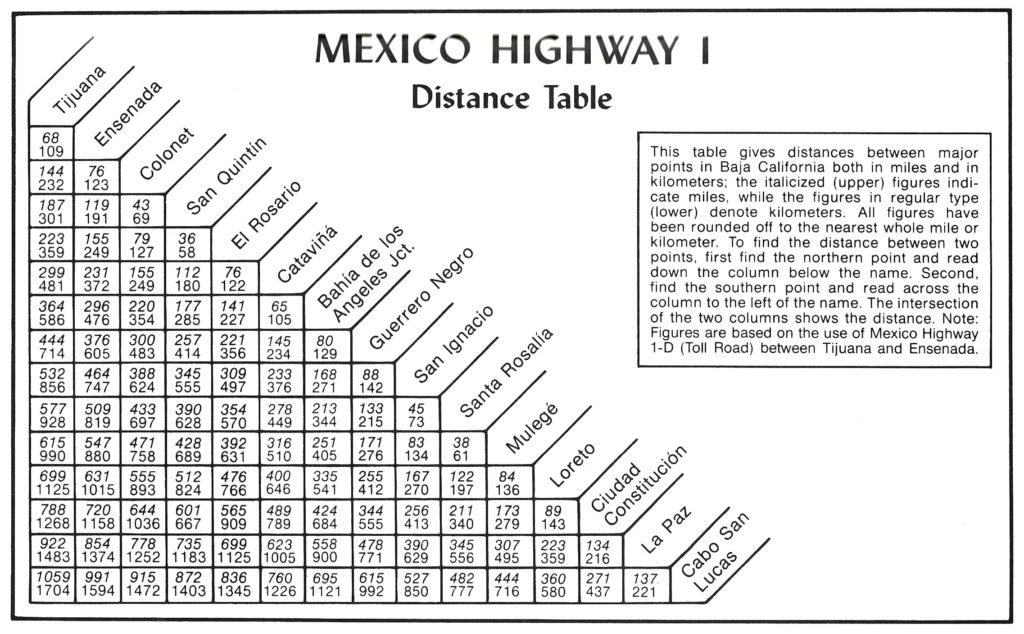
Highway #1 Distance Chart from the Auto Club Maps