JULY 2015: Shell Island, San Ignacio, Bahía Concepción, La Magdalena From July 19 to July 27, Elizabeth and I returned to the beautiful Bahía Concepción of South Baja California. This was the fifth time camping on the beautiful, desert bay for Elizabeth. The previous times (2007, 2009, and twice in 2012) were all wonderful and each inspired us to make the over 600 mile trip once again.
2015 would be different, and while there were many great moments, a few not-so-great ones really took some joy out of this vacation! We both love Baja California a lot, and nothing will keep us away from the magnificent peninsula. Sometimes you just run out of luck for a perfect trip, and it was just our time!
Sunday, July 19: We get on the road at 8:14 am, arrive El Centro at 10:30 am and turn south for Calexico/Mexicali. Just inside the border (Red light/ Green light) we pull over to the left, facing the white INM building (first building on the left, inside Mexico). INM is the immigration department where one obtains a ‘tourist card’, called an FMM. This is similar to a visa and is requested for trips beyond the border zone or any trips longer than 72 hours in the border zone. The FMM is free for up to a 7 day visit and is 330 pesos (US$22) for up to 180 days. The exchange rate was around 15.00 pesos per dollar for this trip. The process was easy… park, walk in the office with your passport, fill the form, pay the fee (if over 7 day duration trip), your passport is stamped, and a receipt is issued. In the past, the fee needed to be paid at a bank, and that could be problematic if there was no open bank teller window nearby. Since 2012, the INM office has been able to collect the fee. The INM officer was friendly and because he needed to go get change, it was maybe a twenty minute process. We left INM at 11:16 am.
On the way out of Mexicali, we stopped to pick up some beer. Tecate Light, Dos Equis, and Tecate Titanium (a new 5.5% alcohol brew) and some complementary ice was obtained. 28 cans of beer was 340 pesos (US$22.67). The highway to San Felipe was excellent, of the 125 miles about 1/3 is four lanes wide and the rest is the newer, wide 2 lanes with paved shoulders that could double as bike lanes. A military operated drug and gun checkpoint is just south of the Highway 3 (Ensenada road) junction, 95 miles from Mexicali/ 30 miles from San Felipe. We are waved through with smiles all around, which is typical. Sometimes, usually northbound, we are asked to get out so they can look for any of the forbidden items (guns, ammo, illegal drugs).
The gas station 7 miles north of San Felipe, by the Rockadile sign, was where I topped the tank. The price of 87 octane /Magna gasoline was 13.57 pesos/liter. That works out to about US$3.45/gallon (about 30-50 cents cheaper than in California). We left the station at 1:55 pm and headed south. The traffic circle in the center of San Felipe is where you turn right to head south. The first 6 miles (10 kms.) is on the airport road to where a left turn is made for Highway 5 to continue south. This point is Km. 0, 10 kilometers south of the traffic circle in San Felipe. We go south about 16 miles from the airport road (or 22 from San Felipe).
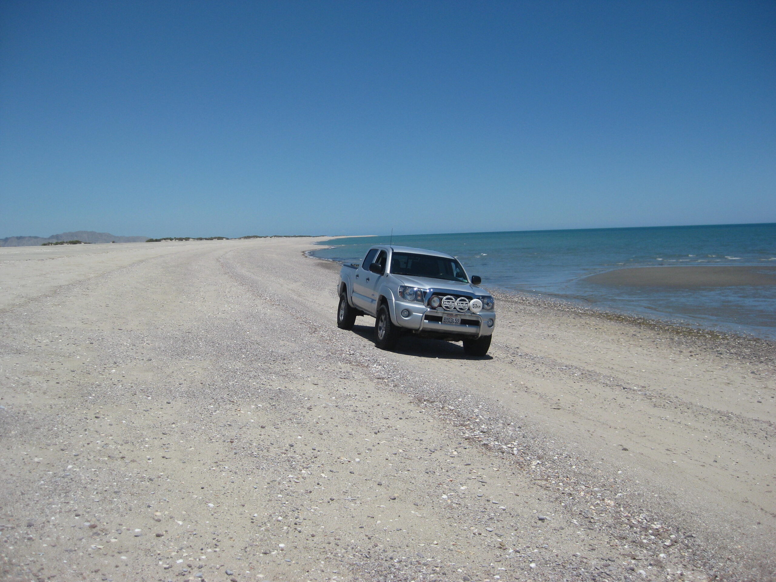
Our first night camp on the beach that I call ‘Shell Island’, as it is a barrier island beach that is separated from the desert by a lagoon that is under water at the highest tides, and muddy much of the other times. The beach is accessed by four wheel drive and there are two sandy roads to it, south of the Rancho Percebu road which is between the Km. 20 & 21 markers.

Elizabeth spots whale bones near our camp. Camp is set up at 3:30 pm, about 45 minutes after arriving. The temperature is 86° and we had some rain on the drive down and again after the tent was put up and later that night, we got more rain, but nothing heavy.

The Coleman Instant tent has been fantastic for us.

Monday, July 20: A perfect, beautiful day! 88° and just a few clouds over the Sierra San Pedro Mártir, to the west. We decide to spend another full day before heading to Baja Sur as the weather is ideal.

The Coleman Instant sunshade is also great, and I have it put up before Elizabeth is out of the tent. She approves! Shade is critical when camping in Baja, especially in the summer.

More bones, these were much smaller… hopefully not a vaquita (an endangered porpoise).

Shell Island, near the north end, looking south.

Our camp near the lagoon side, protected from wind by the sand dunes. Tuesday, July 21: A perfect, beautiful day, again! 92° and no clouds in the sky.

We take a daily drive at low tide to see if anything interesting is exposed by the huge gulf tides.

The usual, sand dollars and seashells.

Getting that “Baja Feeling”!

Tern eggs are often out on the open beach, but these were in the dunes with some protection. They were huge when compared to the parent bird!


Wednesday, July 22: Perfect day, again… but the day you leave is typically the best weather day, so we were not surprised! We leave our beach camp at 8:00 am, and once we are off the beach we have the tires aired-up at 8:30. Deflating tire pressure is needed in such deep sand with a heavy load in the truck to prevent spinning the tires and getting stuck. An electric tire pump is used to refill them and takes about 15 minutes for the four tires to go from 15 psi (back) or 20 psi (front) to the normal street 34 psi.


The Puertecitos road junction is at Km. 74.5, and we pass it at 9:30 am, 52 miles from the San Felipe traffic circle, 30 miles south of Shell Island road. The new Puertecitos roadbed was constructed in 1982 and then paved several years later. It is an old style rural road, very narrow, with many steep dips across arroyos (usually dry washes). It cannot be driven at high speed because of these sudden surprise dips (vados). The paving was originally so thin, it was in ruins by the late 1990’s. It was repaved around 2005-2006.


The viewpoint of the Enchanted Islands is at Km. 99. The highway south of Puertecitos is a totally different story. It is a wide, two lane road with paved shoulders, bridges and culverts instead of dips, and a higher speed limit. This new highway construction began in 2007 and has progressed south an average of 12 kilometers a year, so far. The pavement ends 96 kilometers (almost 60 miles) south of Puertecitos currently and has for the past half year. New construction is ongoing as they blast through mountains for the final 20 some miles to Highway 1 at Laguna Chapala. The alignment is slightly different than of the current road for part of the way. It will be about 2 miles west of Coco’s Corner.

A military checkpoint is located in the Gonzaga Bay area, and we are waved through with smiles. We stop at the gas station located at the road to Alfonsina’s Resort, Gonzaga Bay. The time was 10:30 am. Here gas was slightly different price than all others in Baja, at 14.08 pesos/liter (US$3.57/gallon). Less than 10 gallons tops my tank. On our return trip north, four days later, the station was closed. Never pass an open station without enough gas to reach the next one! Just past the Alfonsina’s road is the Rancho Grande airstrip and road on the left, and their market on the right. The market has ice, liquor, food. Behind it is a tire shop. We get some ice and beer and leave Rancho Grande at 10:53 am.


5 miles south, the highway crosses the large Santa María riverbed near the junction with Arroyo Las Arrastras. A paved exit and parking area with a construction monument overlooks the large bridge from the north rim. On the trip north we stop here for photos.

The end of the paved highway, 20 kms. south of Gonzaga Bay Pemex station, in 2015. This begins an area of huge granite boulders for the next 6 miles to Las Arrastras, the site of a gold ore mill and a former ranch. The foundations remain, and in the arroyo below are the stone mills (arrastras) and well. The highway construction uses the well to fill water trucks. Here the new highway route leaves the former road and heads straight south. The current road curves east and goes to Coco’s Corner, 3.8 miles from Las Arrastras.

The graded road south dates back to the 1980s. Am unimproved, single lane dirt road preceded it.

The old well at Las Arrastras now serving highway construction needs. Note the dust in the distance.

The new highway will bypass Coco’s Corner.

We arrive at Coco’s Corner at 11:48 am and have a nice visit with Coco and enjoy cold Pacifico beer (he also sells Corona). Coco is a landmark here for over 20 years now. Diabetes has caused him to lose both legs, but he manages to get around and has an ATV and truck modified for him to drive. He is close to 80 now and is in high spirit. When I asked him about the new highway bypassing his corner, he expressed pleasure in not having the noise a highway would bring. Coco said the new road is 2.5 kilometers west (1.5 miles). We were on our way at 12:27 pm.


New highway construction was reached 3.7 miles from Coco’s and lasted for 3 miles. The crews are taking down whole mountains from the top to create a straight-as-possible alignment. It may be several years before the last 20 some miles to Highway 1 is completed [It took 5 years]. The current road is very rough, being used for construction vehicles, trucks, and anyone else. With my heavy load of camping gear and ice chests, I had to slow to 10 miles an hour for some of the distance over the mountain from Coco’s to Laguna Chapala. 13 miles from Coco’s Corner we arrived at Highway 1 at 1:03 pm. I aired up the tires (dropped them to 25 psi for the rocky road to prevent flats), and we had some snacks and beer. Southbound at 1:30 pm.

MAP showing the approx. route for the new highway (black heavy line, between the blue arrows). The south end intersection was just a bit more west than estimated above.

El Portezuelo, the pass between the Laguna Chapala valley and the desert south. In July 1973, while the new road was being built, my folks and I stopped here for photos


Hey, who is that skinny 15 year old with a Dick Cepek, Baja Proven shirt on?

The Bahía de los Angeles junction (former Parador Punta Prieta) is passed 30 miles from Laguna Chapala, at 1:59 pm.

A vendor sells gas from cans in front of the abandoned parador building and former gas station (blue truck on right).

Just south, on the east side of the highway is a large fenced area with a sign advertising a future Pemex gas station and Los Pinos market. At 2:40 pm we arrive at Nuevo Rosarito and pull over to the left to have a meal at Mauricio’s Restaurant. Elizabeth ordered the fried chicken dinner and I had the breaded fish dinner; we both drank the Jamaica (“Hah-My-Kah”) tea. This is a sweet tea, also called Hibiscus Tea made from the dried Roselle flower. It is very similar to cranberry in taste. More at: https://en.wikipedia.org/wiki/Roselle_(plant)#Beverage . My fish dinner was excellent, and Elizabeth liked her meal, too. The chicken leg was huge, so we guessed it was a rooster of extra-large size! On the road again at 3:33 pm and the narrow Baja highway begins with a section of newer, wide paving with shoulders for 20 kilometers. A military checkpoint is reached at the El Tomatal road junction and it is all smiles as we are waved through. At Km. 95, about 27 miles from Nuevo Rosarito is a Pemex gas station and the town of Villa Jesus María (new signs call the town Valle Jesus María). Down the long straight highway, we fly and wiz past a truck stopped on the road with a man signaling us… I hit the brakes and back up to see what he needs. His fuel pump is bad and asks if we can seek out his friends at the cattle office (across from the airport road) several miles south, to come help. Happy to assist, we find the office and deliver the message.

20 miles from Jesus María is the 140 foot tall eagle monument, built on the 28° Latitude Line to mark the completion of the Trans-peninsular Highway on December 1, 1973.

South of the Eagle is the newest Mexican state of Baja California Sur (1974), and a change to Mountain Time so we lose an hour on the clock (but regain it on the trip north). The highway has a slight curve right and full stop sign in front of the INM office and agricultural station. We are asked if we have any fruits or vegetables and then asked for 20 pesos to proceed and drive over a spray misting line that is to kill any bugs from the north that may be under the truck. There is no request to see our FMM Tourist Cards, as had been the case on many trips south before. Last trip in 2012, the INM officer just looked out from his open door and waved us on, from the stop sign. 2001, 2007, and 2009 trips all asked to see the official paper here, southbound. 2 miles from the state border/ Eagle Monument is the junction into downtown Guerrero Negro at 4:26 pm Pacific time/ 5:26 pm Mountain time. The highway curves to the southeast for many miles and the kilometer markers now are set south to north, in reverse from the northern state. About 47 miles from the Eagle Monument is the town of Vizcaíno and our next fuel stop, about 190 miles from the last, at Gonzaga Bay. My truck is getting over 16 mpg, and considering the heavy load, speed, dirt section at lower pressure, this is fine. 600 pesos (US$40) tops the tank (44.2 liters/ 11.7 gallons) SAN IGNACIO:


44 more miles and after a military check is passed through, we arrive at the oasis town of San Ignacio, it is 7:10 pm Mountain time. No matter if you need to go into the town or not, if this is your first time, do turn right off the highway on the paved side road into town (across from the gas station, by the whale bones). It is less than 2 miles to the town plaza and mission church, with a crossing of the San Ignacio River along the way. This large body of water comes out of the desert rocks just east and disappears just west of the crossing. This oasis was a huge Indian settlement and 11th California mission, founded in 1728. The giant church made of 4 foot thick blocks of rock, was built in the late 1700’s and is one of the finest Spanish missions to survive the years. Following the independence war of 1810-1821, the Spanish period ended in Baja California. The Mexican government allowed the mission to continue for the local Native population and did so until 1840. The building was used after that year as a parish church and has been preserved with informative signs in English and Spanish. Continue just past the mission and see a new motel in a large grass field, called the La Huerta. A wellstocked market is located at the entrance and sells ice. The motel was exceptionally good, comfortable bed, air conditioning, ceiling fan, and reasonably priced at 550 pesos for a single bed (just under US$40 at a 14:1 exchange). Three remotes (TV, AC, and Fan) in a box, are provided with a refundable 100 peso deposit. Life is good and we sleep well. “Hotel La Huerta” hotellahuertabcs@outlook.es Tel. 154-0116 PHOTOS:


Thursday, July 23: I get up first and take advantage of the morning sun on the front of the mission to get some photos while my bride of 7 years enjoys the rest, on her well-deserved work vacation. A small café facing the plaza by the mission advertises a breakfast of hot cakes, ham and eggs. After checking out, we go there and have a really good breakfast with coffee (180 pesos for both of us). We leave San Ignacio at 11:10 am following a walking tour of the mission with Elizabeth, and buying a handmade purse from the lady in the mission, along with a donation to the mission.
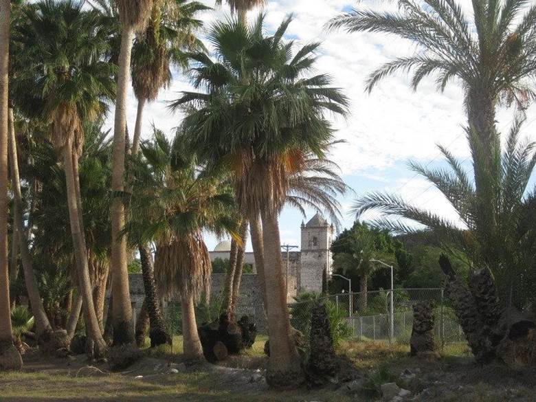
Above: Mission as seen from the motel grounds entrance. Photos of the mission and some of San Ignacio town:


The mission was founded in 1728 and this church with four-foot-thick block walls was built between 1761 and 1786. A construction delay of several years was due to the Jesuits being replaced in 1768.

The plaza is well shaded and the center of social activity in San Ignacio, across from the mission.


We pass through Santa Rosalía at 12:14 pm, 45 miles from San Ignacio. There was a dirt detour along some highway work, less than 2 miles long, about midway between the two towns. We arrive in Mulegé (Moo-la-HAY) at 12:55 pm, 37 miles from Santa Rosalía, and take the left fork under the castle-style wall, into town. A one pump gas station is 0.2 mile from Hwy. 1, and I top the tank here. Gasoline (Magna only) is the standard 13.57 pesos per liter. Passing through town we soon are along the river or estuary. The new concrete road ends 1.6 miles from the Pemex station. The unpaved street continues for 0.3 mile to the El Patrón Restaurant on the water. The sign says open, and I really hope we come back when we are hungry, because it was so good in 2007 and 2009, but closed in 2012.


We are anxious to get on to our camp on Bahía Concepción, so we head on south and plan to buy some block ice at the plant located across from the other gas station south of town. Block ice lasts so much longer than the cube ice sold at most stores in Baja. We are disappointed to find the ice plant no longer in business (the building front is still there). A family has a small beer and bag ice business, so we buy 5 bags of ice and 8 cans of Dos Equis beer, total 192 pesos. We leave at 1:40 pm. I find the dirt road leading to Santa Barbara Cove and the gate is wide open, so we proceed to check out a possible spot. Very soon we come to a truck and boat trailer heading out and are told it is private property and not a camping beach. Great, that saved us from a few rough miles of driving. Next, we go to El Requesón. This is an island with a sand spit that connects to the island at low tide with small palapas on the water’s edge. The sand spit suffered some storm or current erosion and appears to be too low currently to connect. The same palapa or their locations we used in 2007 and earlier I used in 1985 and 1976 are there, and still just above the high tide line. The road to El Requesón now has a large paved ramp off the highway and any vehicle can get to that beach. Even an 18 wheeler was down there! Too crowded, no vacant palapas, so we go ‘next door’ to La Perla and camp at the same place we did in 2009 and twice in 2012. It was 2:21 pm, and other than a day-use family, nobody else was there. Awesome!


We set up the tent first, throw in it our close bags and pillows, and then jump in the beautiful bay water. It was warm but cooler than last time, actually it was perfect! The daytime temperature was in the mid90s and felt great. While floating in the water, we see the typical thunder clouds building up to the southwest, then suddenly we see a downpour out in the bay and can actually hear the rain hitting the sea with great force! All seems to be moving to either side of us, so no panic… yet. When some big drops begin dropping around us in the water and the wind picks up, I get out and add lines to secure the tent. Knowing these afternoon showers are generally brief, I was not too concerned that it would not be much of a problem. Elizabeth got out of the water as it began really raining steady. We both took advantage of the natural shower and rinsed off before sitting down inside the palapa to wait out the rain. It got harder and harder, the wind got stronger, a large waterfall was pouring off the mesa a couple miles west, the rain began to blow in sideways, hitting us in the face, as we huddle well under the palapa. The tent is really being pushed on by the strong, tornado-like wind and we can see that the clothing bags are pressed into the sides and may be getting wet. Nothing we can do than wait it out. We estimate the rain event lasted about an hour, and it and the wind moved on. We survived the cloudburst, but inside the tent, our clothes and pillows were soaked! We had a fire and hoped for a better day tomorrow. A car drove up in the dark and a little old lady named Rosa walked up to collect the camping fee (100 pesos). It was buggy as we were on the beach and even saw millions of crawling bugs come out of the sand around the fire. It reminded Elizabeth of an Indiana Jones movie! Elizabeth made the best of it for the time, but she was not going to sleep outside that night and had a comfortable night in the Tacoma. She tried to get me to join her, but I was sure I needed to lay down, so I set up my cot in the palapa, with citronella candles and deet applied (yes, many mosquitos). I actually slept well; unaware the mosquitos were not annoyed by my preventative measures. Friday, July 24: I wake up early and notice that my lips are feeling weird and there is a puffiness under one of my eyes. The deet and candles were not 100% effective and I am guessing I look like the Elephant Man somewhat? I go to the Tacoma passenger window; Elizabeth is awake, and I do my best Quasimodo impersonation. Other than the mosquitos, I slept fine, and Elizabeth was very happy she slept in the truck! The day is beautiful and sunny. I string up some clotheslines and we basically spend the day drying everything that got wet, with some time swimming in the bay also.


Several years ago, an ‘artist’ outlined the lava on this mountainside. Most of his white paint has faded. It looks like he was seeing coral or seaweed and a whale swimming up?

We decide this would be our last night camping here and will pack it up in the morning (Saturday). Saturday, July 25: We pack up the camp and pull out of La Perla at 11:49 am and take the short drive north to visit with Mark & Olivia at Playa Buenaventura Bar & Restaurant. We see that the hotel next door is deserted/ closed, but Mark and Olivia’s place is open and inviting. They are both there and Mark shares their great news regarding the battle with Muñoz (an out-of-state developer and owner of the hotel next door who has harassed these two for several years with false accusations and physical harm to try and force them off their land, so he could take it over). They long nightmare is apparently over. From what I gathered in our brief talk; a judge has awarded them the hotel (for compensation for the years of hell). Mark said that Muñoz had the rooms trashed and pulled the copper wire out of the buildings before being forced away. If they reopen the hotel, it may only be a couple of the rooms or they may sell it? We take some photos along Bahía Concepción driving north:


We need ice, and the place that sold bags in front of the former block ice plant, was out of ice. I had never been out there but knew about the ‘ice house road’ that heads west from Hwy. 1 in Mulegé. Take the paved road west near the downtown entrance castle. See the signs for Ray’s Place (closed) but keep going straight west. The ice plant is on then right and has blocks or partials for sale. The ice is not clean or potable, just for cooling! In fact, it’s pretty dirty and Elizabeth makes sure we replace it as soon as she sees how bad it looks when some of it melts a day later. I want to check on the Magdalena mission-era site we visited in 2009 that is a few miles northwest of Mulegé. It remains unclear who or when the project was built. Why it was out in the desert and not in the oasis valley where the water is (today’s town of San José de Magdalena) is also strange. Some maps show the site, but not exactly located, as ‘Santa María Magdalena’ (a proposed Jesuit mission, but much farther north). The Mulegé mission was almost moved to this location after floods destroyed that mission’s fields in 1770. The site is at the end of a long aqueduct carved into the side of a cliff and across the desert to a pila (reservoir). Stone, rock and adobe building ruins are nearby… or were. This was an important site, but forgotten by time and in a harsh location, rarely seen by outsiders. Google Earth images show that the Magdalena riverbed widened during a hurricane after our 2009 visit, and took out the building location, but not the pila (yet). The buildings, on both sides of a dirt road were centered at GPS: 27°03’29.9″ -112°10’07.4″ and the pila nearby (we didn’t go see in 2009) is at: GPS: 27°03’29.1″ -112°10’12.3″ Here is one of the buildings at that GPS waypoint, in 2009:

What inspired me to investigate was to see if indeed another historic site was washed away, like at Mission Ligüí in 2001, and document what may remain before it too is gone forever. Here is that satellite images before (2012) and after (2015) the flash flood event. Markers at the building and pila sites:

Just north of the series of bridges, past the Palo Verde airport road, we turn left (west) off of Hwy. 1 just north of Km. 162 (0.4 mile south of Km. 163 if southbound). Some of this dirt road was used recently for an off road race, many arrow signs. Set odometer to 0. 0.0 Hwy. 1 (Km. 162 ½) 0.4 Fork go left (southwest). 3.7 Drive out onto riverbed cobble. Road goes west about ¼ mile, then turns south, crosses water to south side and turns back east passing goat ranch area. See aqueduct along cliff that terminates at the Magdalena mission-era pila, hidden in the desert. 4.4 Fork left off ranch road (ends ahead at blue ranch house) into arroyo bed, soon pass by blue house while driving east in arroyo. 4.8 Park by side gully on south wall of arroyo. Walk south in gully and see pila on right. Walk east from pila to see remains of melted adobe walls next to new cliff, overlooking wide arroyo.


Crossing the arroyo, here called Boca de Magdalena.

Mission period aqueduct carved into the cliff.


The pila (reservoir) at the end of the aqueduct.


So interesting as to why here… This pila will be gone soon as the arroyo continues to widen.

We have an easy drive to San Ignacio and arrive at 5:19 pm. Dinner at Rice and Beans was great. Elizabeth had the Chicken Fajita dinner and I had the Garlic Fish plate (yellowtail). Our dinner, with 4 beers, came to 405 pesos (US$31).

Rice and Beans, San Ignacio, an off road racer’s watering hole! We drove to the La Huerta motel, but a wedding party has filled the place. We stop at the Desert Inn hotel, but they are way too pricey at 1200 pesos for a room. Back to Rice and Beans, and we get a room at Ricardo’s (the owner) for 650 pesos (US$50). Sadly, it is far less appealing than the La Huerta. It has hard bed tops, and live cockroaches. The AC and shower were fine, so we toughed out and got some sleep. Sunday, July 26: We sleep in, it is quiet there at Rice and Beans Sunday morning. Neither of us are hungry so we pass on having breakfast and get on the road at 10:50 am. Rice and Beans now has a direct entrance off Hwy. 1. Before, you would need to go to the first paved road on the right, before the gas station. The town plaza road is the second paved road to the right, just past the gas station. About two miles west of San Ignacio is a military checkpoint, and there are no cars or trucks in line ahead of us. I drive up with the windows rolled down and say “Buenos Dias”. I am asked the typical “Where are you coming from?” (in Spanish) and reply, “Rice and Beans” and “Mulegé before”. I am asked “Got Drugs?” (Not the usual, “do you have guns or drugs?”). “No, no drugs”, is my reply. We are then asked to get out so they can search… and this is typical northbound. The guy asking the question goes immediately to the floor mat and running board and is picking through the gravel and shell bits in the truck carpet from my shoe bottoms the past few days. They have never done that before in all my years. He picks up what looks like a small dark rock, very tiny, and says, “Marijuana?” Of course, my answer is no, as neither of us use Marijuana (or any illegal drugs). Elizabeth is on her side of the truck watching his actions closely, and responds as well, “No”. He then takes a cigarette lighter out of his pocket and lights the tiny object, and it smokes, and he says “Marijuana!” To which I state very clearly, no marijuana, I don’t smoke cigarettes or marijuana”. He has me smell the small burning piece of whatever, and I just shake my head and step back. It is so tiny it is discarded, and he proceeds to slowly search my truck. Now, none of the other soldiers are doing anything and this guy is almost in a joking mood saying things to one other soldier. The others are looking disgusted and have their heads lowered in embarrassment. This guy opens my flashlight to look at the batteries, then the bag my tire pump is in, and not much else. He then looks in my ice chests, giggles to the other guy and says we can go. He was totally messing with us, and if I wasn’t in such shock and wanting to get away from there, I may have insisted on getting his name and comandante’s name. Elizabeth said she looked for a name badge and didn’t see one. This was about 11-11:30 am Sunday. I was not afraid, because unless he planted something on us, we had nothing illegal. I only wonder if the seed or whatever he lit was from the parking lot or beach. But I don’t think it was marijuana or hope not! CLEAN your floor mats before you drive away, each day in Mexico! We drive away stunned to what just happened. I am thinking that if we were newbies to Mexico, that incident would have easily ended any chance to go return. There are just too many great places to drive to in the United States to put up with stuff like this. I love Baja California too much to let any joker in a uniform keep me away. Several miles north, we pull off to make some PB&Js (Peanut Butter & Jelly sandwiches). It was at the side road for San Francisco de la Sierra. Not sure why, but flies by the dozens were being a real nuisance to our lunch prep… It took about 50 miles over opening and closing the windows to get them all out of the truck!

We topped the gas tank at a new station in Vizcaino (42 miles from San Ignacio), on the right (east) side of highway. It had a different price than most of the others (14.20 pesos per liter). The truck took on 51.6 liters for 700 pesos. It was 12:09 pm.

Crossing north from Baja California Sur to the state of Baja California, we got back the hour we lost going south (i.e. 1 pm became 12 pm). We arrived at Laguna Chapala and left the pavement at 1:44 pm Pacific time, 152 miles from Vizcaino. Survey marker for the new highway begin about 7 miles from Hwy. 1. In the hills we encounter two huge dump trucks and pull over to allow them to pass. We pass Coco’s Corner and reach the pavement at the same spot as before, 23 miles from Hwy. 1. I had deflated my tires to 25 psi for the dirt section but decide to wait to re-inflate them at the new rest stop/ viewpoint at the Santa María River bridge, about 7 miles north. We drive slowly with the tires 9 psi lower than normal.


Rest stop at north side of Santa María bridge (called Las Arrastras bridge on signs).


At the fancy rest stop, we take photos as I pump up the tires and Elizabeth points out that a handicap ramp was made to get to the sidewalk, no ramp was made to pass the many steps leading to the viewing platform! On my last tire to refill, the tube gets pinched as I walk away momentarily, and I hear the pump motor make a different sound after a clap noise! Yikes, the back pressure blew a ring or check valve inside the little motor, and it no longer pumped out air! We go to Rancho Grande, get clean ice (70 pesos for one big and one small bag) to replace the murky block ice we bought in Mulegé, and I drive around to the back and get some air for the one low tire. It is 4:06 pm and we drive to Alfonsina’s Resort. The gas station is closed this afternoon, but I think I can make San Felipe on what is in the tank from Vizcaino. A gate is opened to proceed to Alfonsina’s, and we are given a guest pass for the dash. It is 2 miles to the motel/ restaurant/ bar, and it is busy, but we have a nice seat on the deck. A family is playing in the water and manager Antonio comes out to greet us after we get seated by a very friendly waiter. Ice cold Pacificos and garlic shrimp dinners are ordered.


Two shrimp dinners and four Pacificos were US$42 + tip. We ask Antonio about a room, and the price is posted at US$80. No AC, because no generator, just the breeze off the bay. We pass on getting a room and leave at 5:26 pm. We push on north, and the drive is easy. Because we lost the air pump’s use, we decide to camp at Nuevo Mazatlan, where I have gone camping since 1967 until I found the road onto Shell Island in 1978, and a couple times since, as well. We arrive at Nuevo Mazatlan, and the campground is deserted. We set up in the trees closest to the beach. Nuevo Mazatlan in unique in being a tree shaded campground, next to a big sand beach. The trees were planted in the late 1960’s by Nuevo Mazatlan founder Luis Castellanos Moreno. It is an oasis in the desert! We get there well before sundown and have time to just relax in our chairs before setting up the tent and air mattress inside. Later, a small fire is made with artificial logs and the early evening is peaceful and quiet. What a day this was!!!


Headlights approach, and we hear a “Buenos noches”, I reply with same… then say, “Javier?” Si, Javier! The owner of Nuevo Mazatlan, Javier, since 1984 visits with us. I relate my history here at his camp and how Luis worked so hard growing this forest here by the beach before other camps lined this now occupied coastline. While talking with Javier in the dark, something very hot is on my left foot… but I am not near the fire??? It is tiny ants, and Elizabeth identifies them as Fire Ants. Fire indeed! It takes 4 days for the swelling and itching to end, after the burning the first night. Tea tree oil helps greatly, but Elizabeth hates the smell! We spray the tent base very well and have no further problem with them. I just happened to be standing on a nest too long! What a day!!! Camping is $20 per night, and that includes running water (faucets and sinks are piped throughout the campground), showers (not heated, that’s not needed), and flush toilets. I made a web page to show the camp, a few years ago: http://vivabaja.com/nm Once the local dog stops barking, we sleep well… Home tomorrow!

Monday, July 27: I wake up to catch the sunrise over the Gulf of California (Sea of Cortez) and snap a photo, then a little more sleep before we get up for breakfast and pack up the truck, one final time for this trip.


One last photo of Campo Nuevo Mazatlán as we drive away. We leave Nuevo Mazatlán (Km. 32) at 9:42 am. In San Felipe, I pull into the oldest station in town, which is on the right as you enter to the traffic circle from the Hwy. 5 south/ airport road. The price is for Magna (regular, 87 octane) is 13.57 pesos per liter. I get 65.85 liters for 880 pesos that took me 289.4 miles from Vizcaino to San Felipe. My truck got 17 mpg on this stretch, and that is great considering the heavy load, although lighter than the trip south. That Pemex station was taking dollars at 14:1 (pesos per dollar). Other San Felipe stations had 15:1 signs up. There is one more military checkpoint to pass through, and it like the others at El Tomatal and Gonzaga, were great, with no inspection. The San Ignacio northbound experience was the only black eye on of the entire experience on this and all other previous Baja trips. We decide to cross north at Mexicali instead of our usual Tecate northbound border. We get to the end of the line at 1:17 pm. The temperature is 104°F, and after mostly idling for half an hour or more, my temperature gauge climbs a bit above the normal place (but never into the red) and the AC no longer blows out cool air. We are tough and turn it off and lower the windows. Elizabeth sees a lot of neat and different gifts being sold by the walking vendors. About 3 blocks from the U.S. border crossing, we are shocked to see three men perform an act that could rival a circus performance! They create a human ladder and one man goes over the fence, using a rope or sheet to lower himself safely inside America. He then runs quickly into a Calexico back yard. The border patrol truck comes screaming to the fence and then zooms around the block. That’s a first for us. I see other cars taking pictures with their cell phones or iPads.


Once at the border, we are asked what we are bringing back and waved inside the country at 2:29 pm. 1 hour and 12 minutes at downtown Mexicali/ Calexico. An early dinner or late lunch at Golden Acorn Casino was excellent. The $7.77 prime rib dinner with baked potato was yummy. We filled up the truck at the San Marcos Costco ($3.75/ gallon), 261.8 miles from the San Felipe fill up, getting 15.6 mpg. Pulled up to our garage at 6:22 pm. Total miles on the odometer since leaving here: 1,448 miles. Conclusion… The Good: Great beach days (except for the rain part); Visiting with Coco; Honest gas pumps (from what I could tell); Seeing the Magdalena site remains; La Huerta motel; The Food; News from Mark at Buenaventura; Alfonsina’s restaurant; More! The Bad: Rain soaking our clothes and pillows; Mosquitos, beach bugs and Fire Ants! The Ugly: Military checkpoint at San Ignacio, but just the one guy messing with us for laughs. THE GOOD WINS! vivabaja.com