Here is a repost, with edits, of a 5 part trip report covering Agua Dulce, San Juan de Dios and almost to Sal Si Puedes Canyon!
Baja Weekend Part 1: Do you know the way… to Agua Dulce?
This was a rare trip for me, as I almost always have a friend or a child along. Well, the kids were with others, my lady friend had appointments, and a couple amigos I called couldn’t break away (I didn’t give them much advance notice).
I left Oceanside at 5 pm Friday and had traffic all the way to the border, and then a line getting into Mexico, to boot! It was dark and raining all the way to Cielito Lindo, San Quintín, Friday night. I drove up to Gypsy’s indoor camping building, put up my cot and was soon asleep. Only a couple of RVs were parked there.
I awoke to a drizzly day, but I was dry thanks to Dave and Juanita’s great idea of indoor camping. A camp dog was curled up by my tote bag when got up.
Laura was in the Wet Buzzard kitchen, and I ordered two chorizo breakfast burritos. I drove all the way to Cielito Lindo that night just for Laura’s cooking. They are also only $1 each, fantastico!
On the road in the rain to El Rosario, to top the tank. Price of Magna Sin (regular) is MN$5.59/ liter and the exchange rate is now ten pesos per dollar, so the price of gas dropped to US$2.13/gallon. The rain stopped as I wound through the boojum hills, and by San Agustin the sky was blue! This was Saturday morning… Trash (basura) cans are now placed along Hwy. 1 in the hill area… hope that will help!
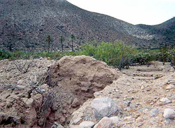
AGUA DULCE was an important source of water to the original inhabitants of Baja, as well as the Spanish explorers, missionaries, and early Baja travelers. It is on the El Camino Real midway between Misión Santa María and Misión San Fernando Velicatá. Junipero Serra and Arthur North both wrote about Agua Dulce in their journals. In the Baja days before Highway 1, my parents and I camped there one night, in 1966, as it was just a quarter mile off the old main road. We were in a Jeep Wagoneer heading for the tip of Baja (a two week trip, then). The next trip to southern Baja was in 1973, and the construction of Highway 1 was going at a feverish clip. Water was needed for construction, so a road was graded to the spring 2.4 miles from the new road’s route. We were detoured on to this side road and ended up at Agua Dulce, again! Unfortunately, they bulldozed the gully containing the spring and it was an ‘ugly’ site.
This trip, I wanted to find this (once) famous water hole, again! Using a sharp eye and noting the mileage given in the Baja California Guidebook by Wheelock and Gulick, I found the turnoff… barely! Two deep gullies almost stopped me. But, with some road building and the Tacoma’s locking rear differential, I got through. I arrived at the old main road after 1.6 miles, then the fork to Agua Dulce was 0.5 mile beyond. I will provide GPS and mileages at the bottom of the page.
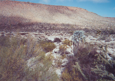
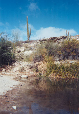
The spring is in a gully, and vegetation had all returned. The damage done in 1973 was not noticed; even the road into the gully was greatly eroded and only serves the cattle who come here to drink the ‘sweet’ water. One tall blue palm really stands out, as well. I was happy to see how well nature reclaimed and repaired the spring. I walked down to the large pool and took some photos and GPS readings. The next two hours, I walked the El Camino Real east, a ways (just a cow path here), then circled around the gully. I saw many clamshell fragments in the desert, not yet fossilized. It may have been left from natives or more recent visitors, who enjoy seafood? I also climbed almost to the top of the south mesa for a bird’s eye view of Agua Dulce. That’s when I noticed an Indian trail going up the opposite mesa! Baja is just so wonderful a place for exploring… I will return to Agua Dulce!
My next stop was Rancho Santa Ynez (Inés), and I decided to use the old Baja main road as far as possible.
But first…here are some GPS waypoints & mileages [If you have the ’97 Baja Almanac, see map N-19(E-5); or the ’86 or ’91 Topo Atlas map, see B72(C-2)]: The highway is actually 1-2 miles south of where it is drawn between Sonora and San Roque. The Almanac and older Topo Atlas just ‘paved’ the old road rather than showing the exact highway location.
The highway construction water truck road to Agua Dulce is 5.4 miles from Café Sonora, (Sonora is just past the signed road for El Mármol). Just past Km. 157 the highway crosses a gully and the faint road goes off to the left (north-east). GPS (NAD27) is 29°52.59′, -114°51.69′. The once graded road crosses two deep washouts (4WD) and goes 1.6 miles to the old main road (29°52.99′, -114°50.11′), where you turn right (east). Go 0.5 mi. on the old road (note house-trailer off to right) and it brings you to the Agua Dulce road (29°52.81′, -114°49.58′) where you will turn left (north-east). Agua Dulce is 0.3 mile away at 29°52.97′, -114°49.38′. This waypoint is taken at the pool, down in the gully. The road ends on the south side of the gully. The tall, majestic blue fan palm will tell you you have arrived. [Three years later, I returned to Agua Dulce using a better road, from Km. 160.5 on Hwy. 1]
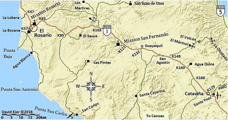
Back on the old road, it is a pretty good drive all the way to where it ends near the cave painting parking area/palapa two miles from Cataviña. The other direction from Agua Dulce on the old road (towards Sonora) is very bad, with deep ruts/high rocky crown. In 2000, the Baja 2000 ran through here, as did the old Baja races before Highway 1 was built. See the Baja 2000 map at the bottom of this page.
The old southern route out from El Mármol joins in 2.4 miles from the Agua Dulce road, it is marked by a small pile of rocks (29°51.34′, -114°48.52′). 1.8 miles further is the original La Virgen shrine and once a tiny store served travelers was across the road, 29°49.87′, -114°47.97′. A road branches right to Highway 1, a mile away at 29°49.41′, -114°48.63′. Continuing south on the old main road, it passes through some interesting boulder fields and reaches Highway 1 at 29°45.15′, -114°44.75′, just north of the Pictograph parking area, or about 2.4 miles from Cataviña.
It was about 1pm and I headed straight for Santa Ynez, for some machaca tacos from Matilda. Marvin Patchen just had his new book published called ‘Baja Outpost’. It contains the notes and messages from dozens of travelers who have stayed in his cabin (Graham Mackintosh was the most frequent guest), which is in the ‘neighborhood’. I showed Matilda the new book and then enjoyed my tacos. Marvin invited me to use his cabin, but it was early and I decided to drive the easy 100 miles to Bahia de los Angeles for dinner and the evening.
Baja Weekend Part 2: Santa Ynez to Camp Gecko
It was 1:30 Saturday afternoon when I finished my taco plate at Rancho Santa Ynez (Inés). I was elated over my success at finding historic Agua Dulce and driving the pre-Highway One, main peninsular road from there almost to Cataviña. I toyed with the thought of going back to Misión Santa María, but I decided to wait until I had new tires and another vehicle along. So, I headed to Bahia de los Angeles, only 100 miles away.
About 7 miles from Santa Ynez, and just past Café San Ignacito, is Rancho San Martin. San Martin now offers gasoline for sale, should you pass Alfonso’s gas stop at Cataviña and have a need. Alfonso also sells Premium in addition to Magna Sin (regular).
Passing El Crucero (where the old gulf road via Calamajué joins Highway One) I noticed some serious off road racing pit vehicles, as El Crucero is on the Baja 1000 course (Nov. 21). The course parallels the highway a mile east, then uses the old L.A. Bay road to where it joins the new L.A. Bay road for about 30 paved miles into L.A. Bay.

Leaving Highway One on the new L.A. Bay road, I was surprised that brand new pavement now extended 14 miles east and the next dozen miles were being totally re-paved, with the old pavement removed and new base dirt rolled on. A federale bust was taking place at Agua Amarga with the black uniformed police arresting some would-be smugglers. I was searched here, for the first time on this trip. The last 16 miles into town was badly potholed, so some dodging was necessary.
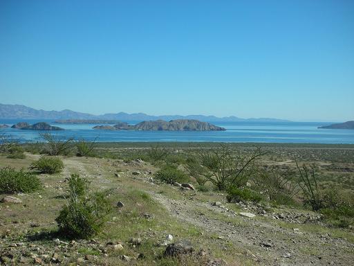
The view of the bay, islands and Sea of Cortez was spectacular, as usual. Except for a few pre-runners, the town seemed empty. The new Internet café is at the intersection where you turn left off the asphalt for Camp Gecko and San Francisquito, across from the ‘super market’ (Xitlali). The four miles to Gecko was normal washboard, which smooths out at 50 mph with my Bilstein shocks. Along the way, two quad pre-runners passed me!
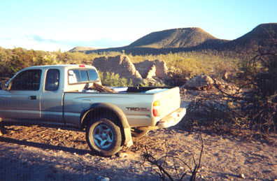
Doc has a new iron gecko lizard sign advertising the entrance to Camp Gecko. Neither Doc nor Sylvia were there; so I drove next door to say hi to Beach Bob. Beach Bob was quite surprised. He was in San Diego recently and had emailed me about his truck purchase. So, I said I had to see his new truck… since I was in the ‘neighborhood’! We went to Las Hamacas for an excellent dinner. I had the Pescado Las Hamacas (includes bacon wrapped shrimp) and Bob asked for a cheese enchilada but they brought him the full dinner plate of 3 enchiladas, rice and beans. Both our dinners came with some great soup, plus our four beers, all for $20.50. I slept well on the beach under the stars as the weather was perfect!


Sunday morning I said my goodbyes to Bob and his friends, after Bob had fixed us a great breakfast. I stopped at Alfredo Diaz’ gas depot and bought 5 gallons at $3/gal. The federales were gone and it was an easy trip back to Highway One. I had some exploring to do about eight miles north of the intersection.
Baja Weekend Part 3: Sal Si Puedes, NOT!
While at Beach Bob’s, we discussed exploring Baja. He told me of a neighbor and friend who wanted to go into Sal Si Puedes canyon, north of L.A. Bay. This was the palm-lined canyon made famous in Erle Stanley Gardner’s 1961 ‘Hovering Over Baja’. Sal Si Puedes translates to ‘Get Out If You Can’! To Erle and others it meant Get ‘IN’, if you can! Earlier this year I emailed with a Baja explorer who did get to Sal Si Puedes from Highway One. I told Beach Bob to tell his friend. I even had the GPS data for the ranch on the mountain above the canyon and the canyon’s headwater. I decided to visit the ranch and see the top of Sal Si Puedes.
About 8 miles north of the L.A. Bay highway junction with Highway One, the old L.A. Bay road crosses the highway, going to the southeast. At this same point, a newer road was graded and reached Highway One going off to the northeast (GPS NAD27: 29°09.59′, -114°08.63′). This is Km. 270 on Hwy. 1.
It was a smooth, easy climb up the long slope. The Baja 1000 parallel road is crossed 1.3 mi. from Hwy.1. A corral and new well is passed 3.2 mi. beyond that crossing. The road gets a little bumpy as it winds through some boulders at the foot of the mountain. Then, around another bend, my heart sunk… a locked gate! I was 7.1 miles from Highway One and 2/3 the way to the ranch and Sal Si Puedes. BUMMER!!! I climbed the boulder-covered hill to scan the area. I could see the mountain next to Tinaja de Yubay, about 6 miles to the south-east and the road I wanted to drive climbs further up the mountain. The gate is at 29°12.75′, -114?03.19′, elev. 2,600′ (that’s a 1,100′ climb from Highway One). I drove back a couple miles and stopped to hike around a bit and found lots of quartz.

I got back to Highway One and turned north. At El Crucero (29°14.30′, -114°09.28′), Km. 261, the race pit vehicles were gone, but a rancher’s truck was there, driving through a new gate. If this is ever locked, the old road from San Felipe, Gonzaga, and Calamajué Canyon would be closed at its southern end! I spoke with the man, and he said his new ranch house was nearby and his ranch was also called El Crucero. I showed him a photo of the original El Crucero taken in the late 1960’s. I expressed my concern for all the new fences along Highway One and gates over roads. He said his gate would not be locked. But, if it was, one could get to Calamajué by going 6.5 miles north to the water truck access road built for Highway One’s construction at 29°17.52′, -114°14.30′. I mentioned my attempt at reaching Sal Si Puedes was cut short by such a gate. The ranch at the end of that road is called San Luis, he said. Baja was once known as the land with ‘hardly any fences’… That too, is changing.
Baja Weekend Part 4: Beyond San Juan de Dios
Sunday afternoon going north on Highway One, I stopped in Cataviña to buy some gas from Alfonso ($3/gal for Magna). He also sells Premium. He said in about a month, the Pemex pump in front of the hotel (across the street) would once again be working. Alfonso was not disappointed by the prospect of being no longer needed. He said he would go fishing and enjoy life!
I stopped at many side roads to add GPS data and to map the relationship of Highway One to the old main road. The Baja Almanac and Topos are all wrong in the San Agustin to Cataviña area. They just paved the old road on the map, which is a mile or more east of the new.
Between Km.103 and 104 is a café on the north side of road. This is the start of today’s adventure… The road to San Juan de Dios and other interior places begins here. The road first goes up the slope behind the café. This road has several forks and no signs! Sony Espinoza’s tractor and some copper mines are soon passed. The first fork is 2.5 miles from the highway, here turn left. The Sauzalito copper mine/ ghost town is another mile down the road at 30°05.9′, -115°21.8′. The road turns north and crosses the San Juan de Dios river 1.3 miles from Sauzalito. In July of 2000 there was much more water and a pond with ducks! Just 0.2 mi. past the river is the next fork. Left is a rarely used back road to El Rosario, go right. A major fork is reached 0.5 mi. from the river. Left goes to Los Mártires and on to San Quintín, on the Baja 2000 racecourse of two years ago (see Baja 2000 map at the bottom of this page). Stay right and pass through an awesome boojum forest that rivals any in Baja! I stopped along here and made myself a late lunch (2pm).
A rancher and his son drove up in an older Toyota 4WD truck and stopped to check on me. I told him I was going to San Juan de Dios and that I knew Sony Espinoza (who owns the land). ‘Lorenzo de Baja’ and I met Sony and his family two years ago when he was using that tractor to build or repair roads. I asked about the road to San Quintín over the mountains… muy malo? He said “sí” but looked at my truck (also a Toyota), and said “no problema”! “Sí, sí… (I replied), Toyota es numero uno”. It was a special moment!
11.6 miles from the highway (5.4 from the river) is the next fork. To the left is a ranch, down in a valley, go right. A half mile later is an open gate and another road left to the ranch. The road is now traveling east and a third road comes in from that ranch at the bottom of a grade. 15.6 miles from the highway, at 30°10.73′, -115°15.55′, is a crossroad. To the right goes to Cerro Blanco. Continue ahead.
Now, the next fork is a big one, and I took the wrong branch. It is 1.3 miles from the last one, at 30°10.98′, -115°14.27′. Right goes to San Juan de Dios, I went left. This would end up being an interesting mistake.
I had read about El Sauce de Carter in Walt Peterson’s Baja Adventure Book. This left fork goes 5.1 miles to the Arroyo Grande and El Sauce de Carter is in a stand of tall trees, just to the left, along the (now dry) river bed. ‘Sauce’ in Spanish means willow tree. Peterson tells of a 5-mile hike up the riverbed to a beautiful gorge with tall trees, blue palms, and huge pools. The road on the map ends here… but a well-traveled road crosses the river bed going north. I go north! 1.3 miles from El Sauce de Carter is a major fork (30°15.45′, -115°12.98′). Both branches seem to go on forever. I take the right branch as it is heading straight for Matomí mountain! Having been in Matomí Canyon several times (on the other side of the mountain), this interests me. I would love to find a short cut across Baja… would this road take me to Puertecitos? Nope! I arrive at a gate…. again! I am 2.8 miles from Arroyo Grande (Sauce de Carter) and must turn around. In the Baja Almanac go to page N-16, Z-6, this new road’s gate is almost at that bend in the trail shown going north to ‘La Huertita’. Mount Matomí looms just beyond. So near, yet so far!

I turn back, get back to ‘right’ road and arrive at San Juan de Dios 4.9 miles from the Sauce de Carter road. I have time to re-examine the ruins there and the other adobe ruins that Jack Swords found, a mile beyond, just as the sun sets. San Juan de Dios is about 22 miles from Highway One over a mostly good road. The waypoint for the mission visita ruins (WGS84) 30°10’57.6″ -115°10’04.5″ are also on my web pages, along with dozens of other new and historic photographs. The links are on my Baja website, http://vivabaja.com. GPS waypoints on the Missions page are set to map datum WGS84. Waypoints in this article are set to NAD27, so you can plot these spots on the topo maps.
Baja Weekend Part 5: Late Sunday Afternoon:
I have a simple camp set up and it only takes minutes. So, I wasn’t concerned at it being almost sundown when I found a spot next to the San Juan de Dios riverbed, near ‘Jack Sword’s’ adobe ruins. I have a big plastic storage box with my ‘kitchen equipment’ and dry food in. An ice chest. A tote bag with a tarp, air mattress, electric pump, etc. All in the back of my truck. Along the way, driving in, I picked up lots of firewood (without being stung by a scorpion). As it was a beautiful clear day, I thought a campfire would be nice. My propane lantern would be put to use in the moonless night and it needed the mantles replaced. No surprise after the roads I was driving on today! The nut, which holds the lid of the lantern on, was so tight I couldn’t loosen with just my fingers. I had an adjustable wrench, screwdriver, but no pliers! As it was getting ever so dark, I struggled on how to get the nut loose. I had plenty of battery powered lighting, mind you. But, it was the point that mattered: this lantern was to be used on this night in Baja, and that was final! I was about ready to break the glass when the nut broke loose… hurray! I made my bed in the truck’s bed rather than put up my tent.
The stars would be beautiful, and it wasn’t a bit cold. The fire was started, the lantern lit, my camp chair set, and a fun book to read (‘Mi Baja No Hurry No Worry‘ by Bernie Swaim). I wasn’t very hungry after eating two sandwiches at 2 o’clock. The desert was so quiet… not a sound. Some people might be scared, I was at peace. The book was almost finished when I decided to cook some stew so I wouldn’t wake up hungry in the middle of the night. The hot beef stew, fruit salad, and cold milk made a great dinner. I finished the book and just enjoyed the fire and starry sky before getting in my sleeping bag.
I don’t know what time it was but the temperature sure dropped and a heavy dew had soaked the outside of my sleeping bag. If I knew that would happen, I would have put the tarp over the truck bed or used the tent. It started out such a pretty night, but I was not happy now! Before sunrise, I was loaded up and on my way home… heater on full! The time was 6 am when I left San Juan de Dios.
I stopped at Sauzalito, picked up some copper ore, and looked around a bit. Highway 1 was reached at 7:40. Filled up at El Rosario Pemex, and pulled off at the Observatory road to make an early lunch. I talked to a couple guys who had just camped up at Rancho El Coyote after getting through from Mike’s Sky Rancho. The new pavement off Highway 1 ends in a few miles, at San Telmo (de Arriba), they told me.
At the military check south of Maneadero, I was asked for a soda by one soldier. He spoke English and told me he worked in Idaho and Wyoming on potato farms. I asked him if his comandante would like a soda too. He waved his hand low, in a negative fashion. I reached the border line (San Ysidro) at 1:00 pm, Monday and was at the border gate in 19 minutes. I was asked my citizenship and what was from Mexico in my truck, and then waved in. Fast and easy!
I am so glad I went south and was able to find what I did. I am assured an interesting adventure anytime I venture into Mexico’s Magic Peninsula: Baja California!
Photos of this weekend’s trip also at http://vivabaja.com/1102.
Baja 2000 Map: