AUTOMOBILE CLUB OF SOUTHERN CALIFORNIA
TOURING BUREAU
SPECIAL BULLETIN
No 214
Date December 11, 1947
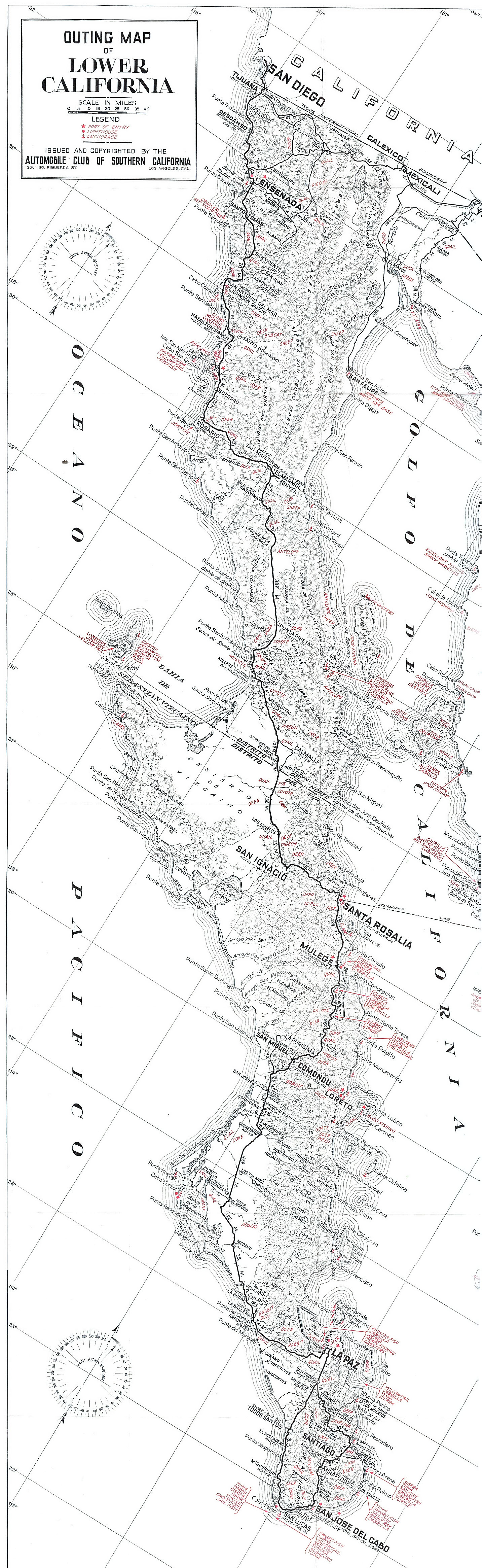
LOWER CALIFORNIA
The following information has been received from our member, Mrs. Don Waters of Anaheim, California who recently made this trip and has kindly granted us permission to reproduce her account of it.
WHILE WE DO NOT HAVE A LARGE SUPPLY OF THIS BULLETIN ON HAND, ADDTIONAL COPIES MAY BE SECURED FOR MEMBERS WHO ARE CONTEMPLATING A TRIP TO LOWER CALIFORNIA.
We would not advise anyone to bring a touring car aside from a Model A Ford, into Baja California south of La Colonia [Vicente Guerrero], The ruts are too deep and the rocks stick up too high for the modern low slung automobile: The local traffic is almost entirely by high wheeled truck, Our outfit is a jeep towing a luggage trailer. The former has stood up well; the latter has broken its springs several times. It is necessary to be well supplied with good tires. The rocks are often sharp and the road bed is hard on rubber. Most of the trucks carry extra gasoline. We had containers for forty gallons more than our thirteen gallon tank.
Although all the way was difficult going south of Hamilton ranch, in general we have found that the worst section was from La Colonia through El Rosario to El Mármol. At this latter village, a good garage is maintained by the marble [onyx] quarry, can repair broken springs and take care of motor trouble. Gas is for sale, a few cents cheaper than at El Rosario where we paid about fifty cents a gallon. There is good water from a deep well. The grocery store has a limited supply of necessary foods which are mostly more expensive than in the States.
From El Mármol south, the road has not presented quite such long precipitous rises nor so many angular dips. It continues to be a track through the desert, in places very rocky, in others deep sand with numerous treacherous holes. To compensate for the condition of the road, the scenery is beautiful. The mountains are bold, some a mile high, and deeply colored. The cactus assume all sorts of fantastic shapes and in sections, the road winds among huge boulders.
We have had no difficulty finding our way along the main road down the peninsula. The signs put there by your organization are still in place at reasonable intervals. We have found the people throughout this country to be without exception honest, and in most cases, everyone has been anxious to help us whether it is to get water, information or just to stop at an isolated ranch for a few words.
Although in most of the villages someone can be found who speaks a few words of English, our halting Spanish has been as useful as we hoped. More than that, it has created good will among our hosts who seem pleased that we have taken the trouble to learn their language. The officials have been most courteous, both the military detail at El Rosario and that at El Mármol. The luggage was not inspected, only our names and the number of the car taken. This is a free state and there are no duties. Camping places are wherever night overtakes one and a good supply of dead mesquite and other hard woods offer a fire for the cold of the upper plateaus.
The wind blows down through this country at almost hurricane velocity at times so that it is necessary, in setting up a camp, to be sure that it is protected from the north. The cactus, some thirty to forty feet high, often break off in the high winds, and anyone struck by these thorn covered limbs would receive serious injury. Some of the dry arroyos look tempting for an overnight stop, yet these same depressions are apt to be swept by sudden floods in case of rain which, however, is infrequent once south of El Mármol.
To give a detailed account of the road is not necessary. You have pamphlets and a map that describe the lay of the country and the villages encountered. At Punta Prieta, there is no store and no regular gasoline salesman. On inquiry, a truck driver offered to sell us some, although we did not accept as we had plenty.
The mail has two stages, converted army vehicles. On Monday of each week one is supposed to start from Santa Rosalia, the other from Ensenada and they pass each other somewhere around El Mármol in the middle of the week. In case of a break down, the motorist need not fear being stranded helplessly. Big trucks haul marble [onyx] from east of Punta Prieta [?] to San Diego making trips weekly. There is also a truck from Santa Rosalia to Ensenada hauling gasoline and provisions which passes over the road several times a month. The delivery of mail is haphazard. If the carrier has passengers to discharge or take on at villages along his way, he stops. Otherwise it seems that he drives on. Often mail is a month coming down the few hundred miles from Ensenada.
At Punta Prieta we left the main road and took the fifty mile run down to the Bahía de Los Angeles on the Gulf of California. There are no signs at all on this road. The directions given us at Punta Prieta are simple and correct. At the several turns where the road forks, always take the right hand one. The left roads go up to mines in the mountains to the north. But the motorist cannot get lost, eventually all the roads lead down to the Bay. This side route to the Bahía [de los Angeles] is about the same condition as the main road with the exception of a precipitous hill or two where the ruts are deep. It is used about once a week by a truck making the run to Punta Prieta.
We hope this account will not discourage motorists from coming south. A pick up truck is ideal, for the camping equipment, extra gasoline drums and water can be carried in it. There are numerous wells along the way, and it is not necessary to carry a great quantity of water. We have formed the habit of boiling our drinking supply as some of the wells are surface water. At El Mármol and La Bahía [de los Angeles], the water is without reproach. Here at the Bahía [de los Angeles], where a half dozen families now live, a few groceries, fresh meat, cheese, honey and game can be had.
Our daily runs are about fifty miles. It is possible to make more mileage, but it is hard on both ourselves and the equipment.
Before leaving Bahía de Los Angeles we equipped our jeep with four leaf helper springs on the rear axle, the luggage trailer with fourteen spring leaves on each side, where we had started with eight. We have new tires all around and two good spares, all brought down from the States. Reinforced springs and new rubber are of primary importance for the peninsula trip, so tire trouble, except in case of accident, can be dismissed from mind.
There are two roads south of Punta Prieta that join again some fifty miles away. One follows down the peninsula, the other swings along the Pacific. We took the latter as it was said to be smoother. It had majestic scenery as we wandered through deep canyons towards the Ocean. Our gas tanks and cans were full. Altogether we carried thirty-six gallons of fuel and ten of water. With the exception of Bahía de Los Angeles, where a clear spring flowed at the foot of the mountain above the dwellings and was piped down to the village, we continued to boil our drinking water. The same was done with fresh milk. Gas could have been procured at Punta Prieta, but we had filled up at the Bahía [de los Angeles] at a high price (between forty and fifty cents a gallon).
We ran up to Calmallí, an interesting village approached from the south by a canyon through which the road winds. In the past, many mines have been worked here. We were told the road coming into Calmallí from the north was impassable and we went down to El Arco and up from there, we learned later the shorter way is open. The village of El Arco is farther south than shown on the map, as it stands at the juncture between the Calmallí cutoff and the main camino.
Here at El Arco is a wireless station and it is used for miles around by those wishing to send messages.
We usually stopped at the ranchos beside the road for a pleasant chat with the people there, and we always engaged the drivers of the few passing vehicles in conversation. It creates good will towards Americans in a country where we are guests, and it certainly pays high dividends since the people of Baja California, relatives and friends, know one another all up and down the Peninsula. Often an American is surprised to learn that his coming has been heralded in advance.
El Arco has gas and groceries, the former still commanding a high price, but it is American gas which has its advantages as we learned later. The desert approaching San Ignacio seems drier than that to the north and the contrast, when suddenly the road runs around the edge of a ridge and reveals the town below, is all the more striking. For here the first homelike beauty is seen, the pueblo of hundreds of date palms, gardens, olive groves and vineyards, all lying between two mesas where an underground river comes up in a succession of long ponds.
The best preserved mission in Baja California stands on the little plaza where luxuriant trees are growing. Every turn in the winding roads is a photograph. Many houses are built completely of palm fronds. The natural flowing water in this desert land is refreshing; there is even a big swimming hole. Gas is between thirty and forty cents, supplies are plentiful, mail service reliable and a good air strip is on top of one of the mesas.
The fuel is brought in through Santa Rosalia and it is Mexican, octane rating is low, and it fouls the carburetor which then floods and causes fire hazards. A fire extinguisher should be carried, but better still, keep the carburetor clean. This gas hasn’t the power that we are accustomed to, and the motor that climbed a steep grade with no knocking, now pings a bit.
The often travelled road into Santa Rosalia is good since it is well kept up. At that copper mining town, it is possible to put a car aboard a boat for Guaymas, but the accommodations are primitive and it is sometimes necessary to wait for days for this transportation. It is very hard to procure white gas for a stove and we used ours little, preferring the hot coals of an open fire at our nightly camps. At the Bahia de San Lucas, twelve miles south of Santa Rosalia near an airfield under some date palms, is a good place to stop.
The road continues on, much the same down to Mulegé, not as bad as north of Punta Prieta, but not as good as between San Ignacio and Santa Rosalia. A few arroyos have loose rocks that don’t appear to present any difficulty, but these should be approached as though they were deep sand, as they slip and slide and the car wheels dig in. Mulegé is pretty like San Ignacio, but it does not come as such a surprise as the first oasis of palms. It is on low ground near the sea shore and there is malaria here.
South of Mulegé the road winds along the Bahía de la Concepción, а beautiful sight.
Approaching Comondú, the road runs to the edge of a mesa. Far below at the foot of the steep mountain nestles the village. This grade is as bad as any encountered. This settlement is two in one [San José & San Miguel], watered like Mulegé and San Ignacio by natural springs. Heading south out of Comondú the road runs through large groves of mesquite in a magnificent narrow canyon with the rocky walls towering up for a thousand feet. During the morning, we encountered our first sand troubles. A truck with larger tires and wider between the wheels would not have as difficult going.
The sand is worse during the day’s drive south of Comondú than at any other place. There are longer uphill stretches of it and some deep spots. But it recurs every now and then in patches till a half day’s run from La Paz.
Gasoline tanks should be filled at Comondú as it is the last regular place where fuel can be bought with the exception of a rancho about fifty miles out of the capital called La Vieja. This is on the beach and not back in the mountains as shown on the map. But to run out of gas is no tragedy. Government trucks ply between La Paz end Loreto and they have orders to help anyone who asks for it. The mail too carries gas, and we procured some from another truck bound north. As in the upper territory, everyone we met in the southern was courteous and anxious to be of service.
There are immense sand dunes along the pacific and the beaches are wide between the rocky coves. Approaching La Paz the road is being worked and the grades are better. At the edge of the mesa, the first sight of the little city is seen set on the bay below.
The clean, picturesque town in itself is well worth the travel to get to it. The mountains make a break here and the high fantastic shaped ridges are not encountered again till south of the bay. The road is dusty, very much noticed in an open car, and to see a car is no longer an event.
La Paz has everything a traveler might want, a small modern hotel with reasonable prices fronting the bay, two motor cruisers for fishing, airmail twice a week as well as service by boat. A couple of new lines are just being inaugurated, a small monthly freighter from San Diego which brings a few passengers, and another is planned; a converted yacht to dock here once a fortnight with thirty passengers. Supplies of all kinds can be procured.
The American tuna boats touch here from time to time and their agent, Fernando Chacon who speaks excellent English, does everything he can to help the American tourist, charging nothing for his services. He has assured us that it is possible to get passage for a car across the Gulf to Guaymas, Mazatlan or Acapulco. In all the length of Baja California, no one has asked to see our tourist permits, but should we cross to the other side, the necessary papers must be shown.
Yet, it was not La Paz that held us, but a couple of ranchos some twenty miles to the east on the Gulf. Here at Saltito and Las Cruces, it seems to us is all the charm of the peninsula. They are reached by a good road that wanders through typical Baja California scenery, rugged ridges of strange shapes, high mesas and pipe organ cactus. Las Cruces lies on a point jutting out into the Gulf with Cerralvo Island off on the horizon to the east. The place is a thick grove of date and coco palms, mango, tamarind, olive and citrus fruits.
The owner, Juan Vives, has several small boats and outboards. There are burros, riding horses and dogs for hunting in the mountains back of the beach. The deer are so plentiful that they come down into the grove during the summer looking for green food. A truck goes in and out from La Paz several times a week. The drinking water is safe. There are no mosquitoes nor flies.
Saltito, the other Vives ranch, a little nearer La Paz, is the new place with a wide sandy beach, groves of thick mesquite, gardens of vegetables. The rainy season is supposed to be mostly during July, August and September, but it has not rained here for three years.
We left La Paz at the beginning of September and the farther south we went, the greener the land became, as it was the rainy season and after three successive dry years, generous showers were falling. These, however, did not affect the road which was far better than in the north. It is mostly sand and the water runs off in a few hours. The scenery appeared less wild to us, probably because we passed through a succession of small towns and ranches occurring at frequent intervals. Water is no problem here as it is farther north. It is best to leave La Paz with full gas tanks and buy gas whenever the opportunity offers.
Several of the villages were old mining centers, now much smaller than they used to be. They are very picturesque lying between the ridges, their fields green from the new irrigation projects. The mountains that make a break at La Paz resume their precipitous ridges as the road runs south. The second highest peak on the peninsula is in this sierra, La Laguna. It rises up against the skyline to the right as the road rears the Gulf. Deer and lion are numerous on La Laguna and many hunting parties go there in the fall. There is good fishing out of Buena Vista. We went down the by-road to La Ribera, rejoined the direct route through a new town called Las Cuevas, about half way between the Gulf and the main highway. This has a shop for the government irrigation department and here a man can, in an emergency, do some work on his car. It was no longer an event to meet another automobile although by United States standards, it is still a lonely road; and we stopped beside it to camp wherever darkness over took us.
We stayed for some weeks at a village two miles south of Miraflores, called Cadauño. It lies in a green valley of cultivated fields watered the year around by springs from the mesas. The climate is healthy and with plenty of fruit and green vegetables, we forgot that Baja California is primarily a desert. From Cadauño we took several side tries by jeep or on mule back into the surrounding hills. The views are lovely, hunting good and there are many interesting spots. One is a place where it is said the Indians covered up the entrance of a d mane to hide it from the Spanish. In another instance hieroglyphics carved into the stone on the side of a ridge. Cadauño has its leather worker who makes the huaraches for the village and its potter to supply cooking utensils for the households. It uses few manufactured articles and life goes on there much as it did a hundred ago under the palm thatched roofs of the homes. The rose colored school house dominates the cluster of dwellings, and as a car turns about the road above this building is the first one to be noticed. The old road used to pass through the village; now the new road swings around it.
Farther south is San José [del Cabo], an enterprising town with a bank (the only one south of La Paz) and well stocked stores. Unfortunately, there is malaria here and if a stop is made overnight, care should be taken to sleep under mosquito netting, something that we found no use for before on our trip. Extensive fields of sugar cane are grown near San José and in season, quantities of tomatoes.
Cabo San Lucas, twenty-five miles farther, is reached by a road that in places winds above the sea looking out over the blue-green water with wide white beaches. This last town on the tip of the arm of land is set in a wide arroyo. It has not recovered from a “chubasco” of several years ago that swept in from the Pacific bringing high winds, rains and floods. During our stay in Baja California in the past summer season, we were fortunate not to experience one of these heavy wind storms that sometimes blow for several days. Then we are told, the arroyos run full and the road is impassable for as long as two weeks until the water has subsided. They can occur during the months of July, August and September and all danger of them is over by the fifteenth of October.
The road west and north of San Lucas to Todos Santos, we were assured, is not used any more since the gale that struck there washed parts of it away and made it impassable. The mail bus returns by the eastern road and we too retraced our wheel tracks. We haven’t yet gone down the Pacific side to Todos Santos which has the reputation of the prettiest town south of La Paz, an oasis with extensive natural springs. From there a trip can be taken on horseback to the top of La Laguna, a matter of six hours. This mountain is unique in Baja California where big pines grow, apples and peaches have been planted in years gone by and naturalists have found rare species of birds. The hunting is good on this side, too.
All during this trip we have met with nothing but friendliness and have found the people honest and eager to do anything they can for an Americano. The only unpleasantness a tourist might encounter is from the government officials in La Paz who are very strict about permits. Six months stay is all that is allowed and then it is necessary to go back to the border for a new card. Other than that and the restrictions about unlicensed firearms, there are no regulations to hamper a visitor.
ARTHUR C. DAVIS
ASSISTANT MANAGER
TOURING, MAP AND LICENSE
DEPARTMENTS
BY: EARLE M. MONTGOMERY
TOURING BUREAU
EMM:rc

