Viva Baja Van Trip #1 June 29-July 7, 2001
The ‘break-in’ voyage of the new 4WD van purchased by Amo Pescar for Viva Baja Tours occured over the July Fourth week. Joining with the van’s pilot, ‘David K’ was his kids (Chris and Sarah), ‘Travelpearl’ (Debra), ‘El Camote’ (Mike), David Eidell, ‘Desert Rat’ (Ron), and from Cielito Lindo to San Felipe: ‘Miguelito’ (Mike Humfreville’s son, Mike).
Two special day trips occurred during this week. The first was on Sunday to Las Pintas when Amo Pescar (Mike), Jeans (Mindy), Michelle and her ‘BHL’ David joined us at that petroglyph and fossil grotto.
The other day trip was on Wednesday from L.A. Bay south 40 miles in search of a lost (proposed) mission site, Santa Maria Magdalena. That day we had as a guide, Jesus Flores, 80 years old, born in Calmallí, Baja California. Riding in the van in addition was Paulina, Mike Humfreville, and Baja historian John Perko.
The week started on Friday, at Cielito Lindo south of Bahia San Quintin for Michelle’s ‘Boojum Buddies Baja Bash’ (BBBB) party.
Then it was on to Paulina’s place on Bahia de los Angeles, near Camp Gecko. A stop at Rancho Santa Ynez for lunch and a hike to Tinaja de Yubay also happened that day (Monday).
Tuesday, we toured L.A. Bay’s museum, the turtle project, Humfreville’s hut site, and swam with a whale shark at La Gringa!
Thursday we headed north for the last camp at Alfonsina’s on Bahia San Luis Gonzaga.
Friday, it was home via San Felipe and Mexicali.
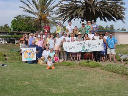
So, kick back and enjoy the photos!>>>> Boojum Buddies Baja Bash 6-30-01
The following 11 photos taken by ‘Bedman’.

Mary Ann Humfrevile, El Camote, Jeans, Miguelito Humfreville, David K…and Sarah K in front.

Earle (of Amigos de Baja), Paulina, Mike Humfreville, & Eric (of Amigos de Baja).

Travelpearl (aka Debra) finally relaxes after traveling nearly 1,500 miles to Cielito Lindo !

Paula (El Jefe’s better half) is showing off her artistic talents .

El Jefe (Tom), Paulina, & David Eidell

Kelly (Cielito Lindo’s manager), Desert Bull (Tim), and the queen of BBBB: ‘M’ (Michelle).
TIME TO KISS SOME ASS!

Here is Jeans, and she is enjoying it! Watching is ‘Rockeeroad’ and Brandi, who is taking a picture.

Michelle has a go!

Paulina does it like a pro!

Even David K has to kiss some ass, sometimes!
BBBB GROUP PHOTO
These next five photos by Sarah K, age 10

David K at Cielito Lindo, with his Viva Baja hat.

Travelpearl (Debra) relaxes before the day’s adventure begins .

Miguelito Humfreville helps load the Viva Baja Van.

El Camote (Mike) adjusts his posture to match the camera’s!

Jeans, Amo Pescar, and El Camote (videoing)
July 1, 2001

Sarah K meets her first boojum at Las Pintas

Christopher K in the dry stream, above Las Pintas

Amo Pescar (Michael) in a Las Pintas ‘squeeze’

The Viva Baja Van and P.O.T. (Poor Old Truck) gang at Rancho Santa Ynez, for lunch. Seated: Sarah, Miguelito, Chris, Mary Ann, Travelpearl, Desert Rat. Standing: David Eidell, El Camote, Mike Humfreville. July 2, 2001
Trailhead for Yubay N29°10.29′ W113°59.65′

On the trail to the historic water hole of Yubay, which is in the canyon ahead. It was very hot and dry, the 0.66-mile hike to Yubay was undertaken by most of our group.
Tinaja de Yubay 7-2-01

Possibly the lowest level this water hole has been in some time. GPS: N29°10.69′ W113°59.26′ (WGS 84) elev. 2,059′. A fig tree grows from the cliff just to my right.

At Yubay, we take a rest as El Camote videos us. But wait….where’s Travelpearl???
Another victim of the trail to Yubay!

Travelpearl’s cell phone is useless in this remote desert. Perhaps the well placed Viva Baja sticker will bring assistance! Very funny Debra !

Happy to get out of Yubay alive, David K kisses a boojum!

The cone shaped hill, as viewed on the return (southbound) trip from Yubay. The desert garden here is incredible!
GPS DIRECTIONS TO YUBAY (WGS 84)
- JCN. hwy.1 & L.A. Bay hwy. N29°02.76′ W114°09.17′ 0.0 mi.
- TURN NORTH onto dirt road N29°04.31′ W114°02.41′ 7.0 mi.
- FORK right (left is Desengaño, 0.3 mi.) N29°06.84′ W114°01.65′ 10.0 mi.
- JCN. go right (ahead to rock palm hill, 4.2 mi.) N29°09.17′ W114°01.40′ 12.8 mi.
- RIDGE TOP, 4WD only beyond N29°10.19′ W113°59.77′ 14.8 mi.
- END OF ROAD in arroyo/TRAIL is straight across N29°10.29′ W113°59.65′ 14.9 mi.
- TINAJA DE YUBAY N29°10.69′ W113°59.26′ 15.5 mi.
- note: mileages are direct, not road miles.
LOST MISSION HUNT 7-4-01

On the old road south of LA.Bay we follow directions given by 80 year old Jesus Flores.

Our companion vehicle, piloted by the aridologist, Mr. Neal Johns.

Beautiful, remote country is found between Bahia de los Angeles and San Francisquito along the old road opened in 1965, by the Gardner party .

Neal Johns searching for the 250 year old Jesuit wall. Santa Maria Magdalena was a mission that was abandoned before it ever was completed. Only a 1757 map lists its existance, no other record is known.

In Valle la Bocana, the Cardon is king!

Just stunning to see these giants in such an arid land!

El Camote and Neal Johns. Not having found the lost mission site, but capturing downpour, thunder and lightning on video makes up for it!

One of many stops to view the flora and mountains

Some of the flora tries to hitch a ride! Stay away from the cholla…also known as ‘jumping cactus’ .

Neal Johns uses his years of desert expertise to render aid to David Eidell, the victim .

Cactus needles are barbed to insure a good grip. David K applied tea tree oil to David Eidell’s wounds to relieve pain and prevent infection .

We managed to escape the canyon before any flash flood. There’s Paulina…always cheerful!

Wild looking country. This is Cerro Las Venecas.

Rattlesnakes beware! Here comes Neal Johns, the aridologist .

Desert Rat and El Camote at Las Venecas .

Looking west, toward Las Venecas where Papa Diaz had a dam built .
LAS FLORES

The only remaining building is the jail.

This narrow gauge railroad ran 7 miles, to the base of the mountain where silver ore was brought from the San Juan mines via cable tramway! The train engine was moved to the town plaza in L.A. Bay.

Jesus Flores pays respect to a friend, Dick Daggett… An entire book could be written about the man who jumped ship, married an Arce girl, prospected gold, and was well known mechanic at Bahia de los Angeles. It was Daggett who informed Erle Stanley Gardner about the Jesuit’s Golfo Camino that might be used as a short cut south. That trip is when Santa Maria Magdalena was discovered.

Senora Daggett next to her husband…

Las Flores bricks and silver ingot molds cover one grave.
Mike Humfreville

Soon to be published Baja author and JPL engineer. Now, if a Mars lander looked like this….hmmmm?

Jesus Flores has a private moment with an old friend .

Desert Rat and Jesus examine the grave behind Dick Daggett’s .

Peek-a-boo Paulina!
GPS DIRECTIONS: L.A. BAY & SOUTH (WGS 84)
- Hunfreville’s Hut at Las Cuevitas: N29°03.30′ W113°32.35′
- Casa Diaz, Bahia de los Angeles: N28°56.77′ W113°33.55′
- Camp Gecko, south of town: N28°54.05′ W113°31.73′
- Las Flores (jail house): N28°49.10′ W113°31.77′
- Jcn. with old road south: N28°40.77′ W113°25.45′
- Arroyo to Las Venecas: N28°39.40′ W113°25.86′
- Site of Paredones, Jesus’ ranch: N28°36.81′ W113°24.59′
- Road ahead to La Bocana & San Pedro, turn sharp left (east): N28°28.40′ W113°23.47′
- We turn right, off road here: N28°28.01′ W113°20.46′
- Tinaja de Santa Maria: N28°26.09′ W113°20.02′
- We hiked a half mile further, but this was not the old mission era site. Santa Maria Magdalena is a bit further east.
July 5, 2001

Desert Rat, Travelpearl, Sarah, and David Eidell pose with Coco at Coco’s Corner.

We say goodbye to Coco and continue towards Gonzaga Bay. Along the way we want to find Tim Walker’s hidden (GPS) treasure…
Baja Boulder Cache

The gang finds the ‘geocache’ hidden by Timothy Walker and his friend Robert. What is a ‘geocache’, you ask? Go to http://www.geocaching.com/ for the details of this GPS hide-and-seek sport.

David K puts his Viva Baja bumper sticker in the cache bucket for the next person to find. Christopher is looking for something cool to take. A log book is in the cache to sign and note the details of the day’s search. When we returned home, I posted the find on the geocaching web site. We were the first ones to find this one!
Gonzaga Bay

Here is the mighty 4WD van on the deep sand beach at Alfonsina’s Resort (N29°48.45′ W114°23.73′). In the background is Papa Fernandez’ Resort, across Gonzaga Bay.
July 6, 2001

The vehicle and its pilot (David K), on one of Baja’s great beaches .

Christopher, El Camote, Desert Rat, and David Eidell check on P.O.T. and the Humfreville’s along the rough road to Puertecitos.

Travelpearl and Sarah, with Isla San Luis in back .

Travelpearl and Mary Ann Humfrville chat, while the guys figure how to keep P.O.T. from losing any more parts on the rocky road!

Rugged coast looking north, towards Puertecitos .

A final look back south to the Enchanted Islands off the coast of this enchanted peninsula! Thank you for visiting this ‘web trip’. I actually have one last roll of film to develop! So, check back, as there may be some more cool Baja pics here! Please visit my web site for past Baja adventures and cool Baja links http://vivabaja.com/