Baja-1-2001 The following photos taken by David K and LdB (and scanned by Wild Bill) are of our trip in Northern Baja from Dec. 29, 2000 to Jan. 1, 2001. The text of the trip can be found on six trip reports posted on the Amigos de Baja Discusson Board at http://www.bajanet.com/general/ ending on 1/9/01. My Baja website contains many photos of my previous two Baja adventures. May, 1999 to Mision Santa Maria with BajaMur and July, 2000 to many locations with Lorenzo de Baja (LdB). Many other Baja photos and links can also be found there. Visit http://vivabaja.com/
Mission San Vicente Ferrer 1780-1833

San Vicente was also administrative headquarters for the northern peninsula for many years. Much restoration work has been done, with much more work yet needed.

Main part of the mission is shown by the foundation rock base. The adobe remains were side buildings next to the main mission building. Photo aimed SW, 12-30-00
Baja’s ‘White House’ in San Vicente

This house was the headquarters of William Walker, who in 1853 proclaimed the creation of the Republic of Lower California with himself as president. We were told this was also the home of Governor Pio Pico after he was driven out of Alta California by the Bear Flag Revolt and Mexico’s loss of Alta California.

From the high point on the road to Valle Trinidad. Photo facing west.
Lorenzo de Baja

Like a rock! LdB poses at the high point. Bruce Anderson soon arrived leading a Japanese motorcycle tour. His website is http://www.gobajaridin.com/
Valle Chico and Diablo Mountain

Mighty Picacho del Diablo and mighty Toyota Tacoma!
DRIP IRRIGATION

Uplanted field under shade trees using drip tape for irrigation.
HOT TUB, Baja Style

Hot Spring location in Agua Caliente Canyon. Photo looking north, down the stream from where we came. The hot stream is to the left of the tub and flows hot for a good distance before joining the cool stream.
Agua Caliente, source.

The shovel was there, next to the spring. GPS is 30-38.846 X 115-12.456 elev. 2,000′
The Spring

Bubbles come up and a large quantity of extremely hot water flows from this spring hole. A couple other springs are close by in the brush.
Steaming streams on both sides of me!

Baja is incredible…here two spring flows of super hot water join and flow about a hundred feet where they join the cool mountain stream.
Fence road across Valle Chico leads to the Parral pass and on to the sulfur mine near the gulf coast.

Looking east across the valley. To the north 9.1 miles is the Agua Caliente ejido, and to the south 8.5 miles is Matomi canyon.
LdB burns a rock!
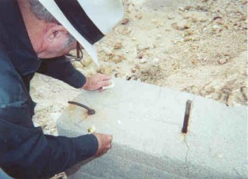
At the El Apache Sulfur Mine, 23 miles south of San Felipe, Lorenzo proves yellow rocks can catch on fire! 12-31-00
My new truck and I on New Year’s Day 2001

On my favorite Baja beach, ‘Shell Island’, about a mile south of Laguna Percebu.
Shell Island from the air, looking south.

BajaMur photo from Doug Bowles plane. Laguna Percebu is to the right of the photo. LdB and I camped a mile south of the tip.
El Promontorio Sulfur Mine
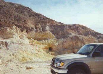
Located 7 miles west of Hwy. 5 at Km.49.
Sulfur Mining Complex

Laguna Salada is in the background. A bulldozer, boiler tanks and a caretaker’s house indicate recent activity.
El Promontorio Cantina?

No Lorenzo, no carne asada today! Well gang this quick Baja trip was a lot of fun and a little dangerous, too! See other Baja adventures on my website at http://vivabaja.com/.