We explored the top half of the La Turquesa Canyon grade, stayed at Gonzaga Bay’s Campo Beluga and then spend the last night on Shell Island. We visited with friends Antonio Muñoz in El Rosario and Rob & Connie at Bahia Santa Maria.
Hwy. 1 to La Turquesa Canyon View

Between Km. 213 and 214, south of the El Pedregoso boulder hill, this rocky track heads east. GPS: 29°31.15′, -114°30.03′(WGS84). This is 97 miles south of El Rosario and 12 1/2 miles north of Laguna Chapala.

The rocky track in the arroyo changes to a smoother road after a half mile or so… It is 4.6 miles from Hwy. 1 to the viewpoint at the top of the grade… the peninsular divide.
La Turquesa Canyon View (29°32.54′, -114°26.06′)

The elevation here is 2,816′ and you can see all the way to the granite boulders where Hwy. 5 is located. The turquoise mine is on the left side of the canyon.
‘Kacey’s XR Ride’/ ‘Coco’s Short Cut’ …

Expecting to find just a trail down the mountain passable only to motorcycles, I was surprised to see this constructed grade heading down into the canyon! Appears to be an old mine road?

Just in case there is no place to turn around if necessary, Elizabeth and I hike down the grade to check it out.

I want to see more of this old road, so Elizabeth waits as I hike further. Using the telephoto, here she is from further down.

Hwy. 1 to Hwy. 5 is about 11 miles. We now know what the west 6 miles look like. On the east end, a road comes about 3 miles from Highway 5, passes the green pools and ends at the turquoise mine. See http://vivabaja.com/wayno and http://vivabaja.com/1102/ for photos and GPS.
Satellite Image of the grade

The old road is clearly visible on Google. I hiked over halfway down, but the bottom was out of view. From the bottom of the grade to the turquoise mine, the road is reported gone, but motorcycle tracks stay to the center (north) side of the arroyo for 1+ mile and pick up the turquoise mine road that leads to Hwy. 5.
Sunrise Sunday at Campo Beluga

Not being able to see the bottom of the grade, and traveling alone (one vehicle) we decided to drive back out to the highway and get to Gonzaga Bay the ‘normal’ way! We arrived at the sea shore just as it was getting dark.
GPS: 29°46.48′, -114°23.01′ (WGS84)

Campo Beluga has a nice set up with palapas, flush toilets and showers. It is located just over a mile south of Alfonsina’s and Rancho Grande.
View north
Our camp

View south towards Punta Final

Bahia San Luis Gonzaga

The view of Papa Fernandez’ camp on Gonzaga Bay from Hwy. 5, as we drive north to spend the last night of the weekend on Shell Island.

Graded but very rocky and rough… Most of the 45 miles to Puertecitos is slow going.

Okie’s Landing

Those concrete pads are all that remains of this 1960’s sportfishing camp.

Isla El Huerfanito

The ‘Little Orphan Island’ is so named because it isn’t near the other ‘Enchanted Islands’ that are off shore between here and Gonzaga Bay.
View south…

There is an abandoned stone house on a cliff high above the sea with an awesome view.
View east…

View north…

Puertecitos is located at the farthest point of land you can see here.
Elizabeth and David

We sure enjoy traveling together…
What a view!

We popped out our chairs and ate lunch here. got tires?

The graded road’s dirt-fill surface has washed and worn away, exposing the sharp volcanic rock roadbed.
Puertecitos

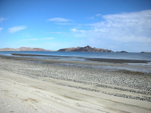
Shell Island

We arrive with plenty of daylight to set up our simple camp for one night.

Looking north, on the lagoon side of the island.

Baja has some really great sunsets. Here looking southwest…
‘Us’
Two people on life’s journey, walking together side by side, their love unites them, their goals inspire them, the future awaits them…

Diablo Mountain


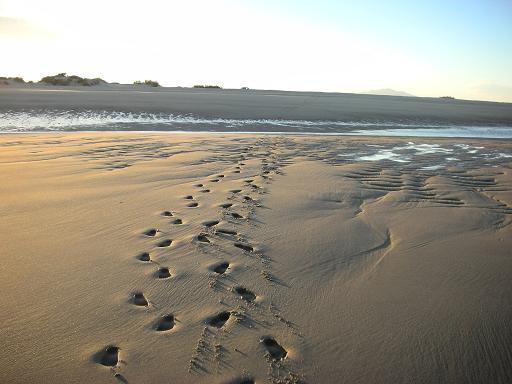
After a really windy night, we woke up to this super low tide.

Not to many places you can walk a mile out to sea! This is looking back to Shell Island. In a couple hours this will be several feet underwater!

Shell Island has been a camping destination for me since 1978. I just love the sand, shells and unspoiled coastline. I always hate to leave!

Photo shows the mud flats between Shell Island and the rest of Baja. You may find deep water across the access road at high tide. Lagoons are north and south of this point .