Elizabeth (‘Baja Angel’) and I were invited to Baja Lou’s turkey feast in El Dorado (north of San Felipe) and Baja Rob’s beach house in Bahia Santa Maria (south of San Felipe)… Great hospitality from Baja Nomads!
We also explored the sulfur mine, Cañada el Parral and blue palm filled Cañon el Berrendo on our way home.
Shell Island

On Dec. 30, 2005 we went to our favorite beach to have a quiet first night campout. We arrived in the dark, after pulling a stuck motorhome back to the pavement! This photo was taken the next morning driving away from our campsite, as we headed for Lou’s party.
Dec. 31, 2005
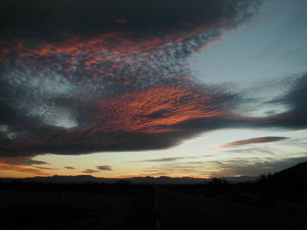
New Year’s Eve gave us another beautiful ‘Baja sunset’. We enjoyed meeting more new Baja Nomad amigos as well as seeing old friends at Lou’s fiesta.
January 1, 2006

What a beautiful place to start a new year, Bahia Santa Maria! The night before, we enjoyed the local tradition of walking from house to house spreading good cheer (chatting, drinking, eating)!
Casa de Rob and Connie

Really nice folks that were great to bring in the new year with! They have a most beautiful home right on the beach.

Friends and neighbors chatting as the sun sets… On the right: Connie, Baja Rob and Baja Angel.
January 1, 2006

The sunset we were watching at Bahia Santa Maria, (Km. 31, south of San Felipe).
Sulfur Mine ‘El Apache’

Located about 5 miles west of Bahia Santa Maria along the old road to Puertecitos. Operations were abandoned over 50 years ago. The ore crusher was located here.

Lots of sulfur is still piled and laying through-out the two mile long valley.
Apache Tears

About two miles south of the sulfur mine and just west of the old Puertecitos road, obsedian fragments called ‘Apache Tears’ can be found laying about. Obsedian is a volcanic ‘glass’ used by Indians to make arrow and spear heads.
Cañada el Parral (Azufre Wash)

Inside the little canyon of Parral are various cactus including the cardon. SCORE has used this passage to race through and called it Azufre Wash. It offers a nice short cut to Valle Chico and the bigger canyons of the Sierra San Pedro Martir.

Geologic pressures curve these layers of rock.
1978

My friend Jim Todd at the same site when we first drove through Parral almost 30 years ago!
Cañon el Berrendo

Maybe should be renamed Blue Palm Canyon! A giant boulder grotto is about a mile hike up the canyon from the end of the (deep sand) 4WD road.

Elizabeth and a young blue palm .

Blue palm seeds

The mountain stream is reached here, just before it goes under the sand.

One of my favorite hikes is here!
Nearing the grotto…

On the ridge, above the canyon, are some very tall blue palms.

Giant boulders create this grotto…

Quite a spectacular site!

Driving back down the arroyo and heading home from another fun Baja weekend!

A young burro and his mama (in Valle Chico near the Berrendo canyon junction) pose for some photos.
Valle Chico Map

The canyons are all worth a visit. From north to south they include El Cajon, Agua Caliente, Carrizo, Berrendo, Parral, Matomi and many more! See http://vivabaja.com/404 and http://vivabaja.com/204 for more on these canyons. More Baja: http://vivabaja.com/